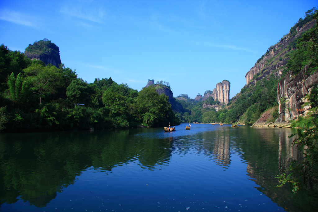
The Wuyi Mountains were inscribed as a UNESCO World Heritage Site in 1999 under both natural and cultural criteria — one of a small number of properties to qualify on all four natural and three of four cultural criteria simultaneously. The inscribed area covers 99,975 hectares in northwestern Fujian Province along the Fujian–Jiangxi border; the mountain range forms a biological corridor between the subtropical and temperate zones and has been identified as one of the global centres of biodiversity for reptiles and amphibians. The Nine-Bend River (Jiuqu Xi), which cuts 62 km through the mountains, has been navigated by bamboo raft since at least the Tang dynasty (618–907 CE), making the Wuyi river tour one of the longest-running commercial tourist experiences in recorded history — roughly 1,200 years before the term “heritage tourism” existed.
The Cliff Coffins and the Tulou Earthen Fortresses 300–350 km south / 3.5–4 h by road or rail
Two of the most archaeologically and architecturally significant UNESCO sites in Fujian Province lie south of the Wuyi Mountains, reachable by rail or road within a half-day’s travel.
Within the Wuyi Mountains inscription itself, the most archaeologically distinctive element is the cliff-coffin tradition of the ancient Minyue culture. Boat-shaped wooden coffins, some containing textile and lacquerware grave goods, were placed in rock crevices or on timber brackets wedged into cliff faces 50 to 100 metres above the river, in some cases at locations that would require technical climbing equipment to reach today. The culture that created them left no written records and is known primarily through these burial deposits and through later Han dynasty textual references to the Minyue Kingdom, which was destroyed by the Han in 110 BCE. Fourteen coffins have been identified at multiple cliff sites within the inscription boundary; the best-preserved are visible from the river raft route in the lower gorge sections. The origin of the practice — whether it reflects a belief that elevation protected the dead from disturbance, brought them closer to spirits, or served some other function — remains under active scholarly debate.
The Fujian Tulou, inscribed in 2008 as a group of 46 earthen structures in Nanjing, Hua’an, Yongding, and Zhangping counties, lie approximately 300–350 km south of Wuyi by road, 4 hours by car or bus. The tulou are large communal earthen buildings, typically circular or rectangular in plan, built between the 12th and 20th centuries by Hakka and Minnan communities in southwestern Fujian. The largest, the Chengqi Lou in Yongding County, is 73 metres in diameter, four storeys tall, and divided into four concentric rings housing up to 80 families — approximately 600 people — in a self-sufficient village unit behind a single exterior earthen wall 1–1.5 metres thick. The walls were built from rammed earth, bamboo, brown sugar, and glutinous rice, a combination that makes them resistant to earthquake damage: the 1918 Shantou earthquake, magnitude 7.3, caused relatively minor structural damage to most tulou in the affected zone. The buildings were treated as anomalies by outside observers until the 1980s, when foreign observers initially misidentified satellite imagery of the Yongding clusters as nuclear missile installations. From Wuyi: the most direct route runs south via Nanping on the Fuyin Expressway, approximately 4 hours to the Yongding tulou cluster. A rail option via Xiamen or Longyan is slower but available.
South to Xiamen’s Colonial Island and West to Chongqing’s Carved Cliffs 350–750 km / 3–8 h by rail
Two further inscriptions extend the circuit: one southwest to the island of Kulangsu off Xiamen, the other far west into Chongqing Municipality.
Kulangsu (Gulangyu Island), inscribed in 2017 as a Historic International Settlement, lies in Xiamen Bay, accessible by ferry from Xiamen’s waterfront (10-minute crossing, ferries run continuously). From Wuyi, Xiamen is approximately 350 km south by road or 3 hours by high-speed rail via Nanping and Fuzhou on the coastal HSR line. The island, 1.88 square kilometres in area, was designated an International Settlement in 1903 following the First Sino-Japanese War, with residential and commercial zones assigned to thirteen foreign powers — including Britain, Germany, the United States, France, Japan, the Netherlands, Spain, Portugal, and Denmark — alongside Chinese merchants and government buildings. The resulting architectural fabric is layered: Hokkien courtyard houses built on the existing Chinese residential pattern, colonial public buildings in European civic styles, and hybrid structures that combine Chinese roof forms with European colonnaded facades and decorative terracotta tiles. Approximately 931 historical buildings are documented on the island; it has no motorised vehicles. The island is also known for its high density of grand pianos — a consequence of the musical education culture established by Western missionaries in the early 20th century — which earned Kulangsu the unofficial designation “Piano Island.” From Wuyi: 3 hours by HSR to Xiamen North station, then 30 minutes by metro and ferry to the island.
The Dazu Rock Carvings in Chongqing Municipality, inscribed in 1999, are 750 km northwest of Wuyi by rail — approximately 8 hours by high-speed train via Nanchang or Changsha and the Chengdu-Chongqing HSR corridor. The carvings number over 50,000 sculptures across 75 sites in Dazu County, carved in sandstone during the Tang (618–907 CE), Five Dynasties (907–960 CE), and Song (960–1279 CE) periods. The most developed section, Baodingshan, was created as a coherent programmatic circuit by the monk Zhao Zhifeng over approximately 70 years in the late 12th and early 13th centuries. Dazu is relevant to a Wuyi itinerary primarily through its connection to the Neo-Confucian philosophical tradition: the Song dynasty was the period when the philosopher Zhu Xi (1130–1200 CE), who taught and wrote at the White Deer Grotto Academy near Wuyi and established his school at Wuyi itself (the Wuyi Jingshe study hall, founded 1183 CE), formulated the synthesis of Confucian, Buddhist, and Taoist thought that became the orthodox curriculum for imperial examinations until 1905. Dazu’s sculptural programme explicitly incorporates Confucian and Taoist iconography alongside Buddhist figures — a visual expression of the same synthetic intellectual tradition that Zhu Xi was systematising in text form during the same decades. From Wuyi: direct HSR connections via Nanping; allow a full day each way.
A cultural connection worth noting extends beyond China’s borders: the Seowon, Korean Neo-Confucian Academies, inscribed by South Korea in 2019, represent the institutional transmission of Zhu Xi’s thought to the Korean peninsula. The Seowon tradition — private academies established from the 16th century onward for Confucian scholarship and the veneration of eminent scholars — was directly modelled on the Chinese shuyuan academy form, of which the Zhuxi academies at Wuyi were the most influential example. The nine Seowon inscribed by UNESCO are in South Korea, not geographically close to Wuyi, but their connection illustrates the reach of the intellectual tradition Wuyi represents: a philosophical system developed in a mountain study hall in Fujian shaped the educational institutions of an entire neighbouring civilisation for four centuries.
Practical information
Reaching Wuyi Mountains: the main entry point is Wuyishan City (formerly Chong’an), served by Wuyishan Airport (WUS) with flights from Fuzhou, Xiamen, Shanghai, Beijing, and Guangzhou. High-speed rail arrived at Wuyishan North Station in 2020 on the Fuzhou–Yinchuan corridor, connecting Wuyishan to Fuzhou in 1.5 hours and to Xiamen in 3 hours. The scenic area entrance and main hotel cluster are in the Wuyi Palace zone at the southern foot of the mountains, approximately 10 km from the train station by taxi.
Best season: October–November for clear weather and reduced summer crowds; March–April for mountain rhododendrons. The bamboo raft tour on the Nine-Bend River runs year-round unless flood or drought conditions force closure; the 9.5-km route takes approximately 90 minutes and covers only downstream. Raft quotas apply in peak season; book through the scenic area ticket office or licensed hotels in the resort zone. The tea-producing area of Wuyishan (Da Hong Pao oolong, Zhengyan wulong) surrounds the core scenic zone; direct-sale tea shops in the resort cluster are the primary retail point.
Combined circuit: a 5-day Fujian circuit from Xiamen can cover Kulangsu (Day 1), Fujian Tulou in Yongding (Day 2), train north to Wuyi Mountains (Days 3–4), then return to Xiamen or Fuzhou for departure (Day 5). Adding Dazu requires a separate westbound leg from Wuyi via Nanchang to Chongqing, practical only if combining with a broader Yangtze circuit.
Frequently Asked Questions
What is known about the people who placed the cliff coffins in the Wuyi Mountains and why are the coffins shaped like boats?
The cliff coffins of the Wuyi Mountains are attributed to the Minyue people, a pre-Han civilisation that occupied Fujian and parts of Zhejiang from at least the Spring and Autumn period (770–476 BCE) until the destruction of the Minyue Kingdom by the Han Emperor Wu in 110 BCE. The Minyue left no written records; knowledge of them comes almost entirely from Han dynasty texts — primarily the Shiji (Records of the Grand Historian) by Sima Qian — and from the archaeological material recovered from burial and settlement sites within Fujian. Fourteen boat-shaped coffins have been documented in the Wuyi area, mostly in locations 50–100 metres above river level, inserted into natural rock crevices or placed on wooden bracket supports driven into the cliff face. The coffins are constructed from single hollowed logs in an elongated boat form; the largest documented examples are approximately 5 metres long. The precise technique by which they were placed — requiring the transportation of coffins and bodies to cliff-face locations with no evident modern access route — has not been resolved. One proposed method involves temporary bamboo scaffolding; another involves placement from above by rope lowering. Grave goods recovered from some sites include bronze weapons, lacquerware, and silk textiles. The boat form has been interpreted as referencing the Minyue people’s strong maritime and river-navigation culture — Fujian’s rivers were primary transport routes, and the sea played a significant role in the coastal economy — but this remains an inference. The practice of cliff-face burial existed in multiple cultures across southern China and Southeast Asia, from Yunnan to the Philippines, suggesting either independent parallel development or cultural transmission across river-trading networks.
What did Zhu Xi actually write and teach at Wuyi and why did his ideas dominate East Asian education for 700 years?
Zhu Xi (1130–1200 CE) spent the most productive decades of his intellectual life in Fujian Province, and Wuyi Mountain was both his personal refuge and one of his teaching sites. In 1183 CE he founded the Wuyi Jingshe (Wuyi Study Hall) at the foot of the mountains, where he lectured to students and completed major textual projects. His core work was the systematic reorganisation and commentary of the Confucian canon: he designated the Four Books (the Analects of Confucius, the Mencius, the Great Learning, and the Doctrine of the Mean) as the foundational curriculum for Confucian education, replacing the earlier emphasis on the Five Classics, and wrote commentaries on each that became the authoritative interpretation. His synthesis drew on Buddhist concepts of mind cultivation and Taoist ideas about the nature of principle (li) to create a Confucianism that addressed metaphysical questions the original texts had not systematically engaged. The result — called Cheng-Zhu Neo-Confucianism or the School of Principle (Lixue) — was adopted as the official ideology of the Yuan dynasty (1271–1368 CE) examination system and remained the framework for the imperial civil service examinations through the Ming and Qing dynasties until 1905. Since the examinations were the primary route to official position in China, Korea, Vietnam, and Japan, mastery of Zhu Xi’s commentaries was effectively mandatory for the educated elite of East Asia for roughly seven centuries. His influence on Korean Confucianism was especially direct: the Korean Seowon academy system, inscribed by UNESCO in 2019, was organised around the veneration and study of Zhu Xi and scholars who transmitted his tradition.
How were the Fujian Tulou built and why did so many families live together in a single structure?
The Fujian Tulou are rammed-earth communal buildings constructed primarily by Hakka (Kejia) and Minnan communities in the mountainous western interior of Fujian Province from roughly the 12th century through the early 20th century. The Hakka — a Han Chinese subgroup whose name means “Guest Families,” reflecting their identity as successive migrant waves into southern China from the Central Plains — settled in frontier areas where clan solidarity and defensive architecture were practical necessities in periods of social disorder. The construction technique, hangtu (pounded earth), involves filling timber formwork in horizontal layers with a mixture of local subsoil, sometimes enriched with bamboo strips for tensile reinforcement, coarse sand, lime, and in some documented cases glutinous rice flour and brown sugar as binding agents. Walls dry slowly and are built up over months or years; the largest tulou required decades to complete. The resulting exterior walls, 1–1.5 metres thick at the base tapering to 0.9 metres at the top, are resistant to earthquake damage and fire. The largest known tulou, the Chengqi Lou (1709 CE) in Yongding County, has a diameter of 73 metres and houses four concentric rings: the inner rings are lower-floor service buildings; the outermost ring is four storeys of residential cells, each floor connected by a continuous interior corridor. The ground floor of the outer ring contains kitchens; the second floor is storage; the third and fourth floors are sleeping quarters — a standard layout designed so that no external windows below the third floor gave projectile weapons no entry points. The buildings were primarily defensive against bandits and inter-clan violence rather than against organised military attack; the single heavy main gate and the absence of ground-floor exterior windows were the primary security features.
Sources
- S1 — UNESCO World Heritage Centre — Mount Wuyi (Ref. 911) — https://web.archive.org/web/20230601000000/https://whc.unesco.org/en/list/911/
- S2 — Wuyishan Scenic Area Administration — https://whc.unesco.org/en/list/911/
- S3 — Seidensticker, John. <em>Riding the Tiger: Tiger Conservation in Human-Dominated Landscapes</em>. Cambridge University Press, 1999. ISBN: 978-0-521-64835-6.
Spotted an error? Write to editorial@culturalheritageonline.com and we correct it the same day.