Petra is the capital of the Nabataean Kingdom, carved from rose-red sandstone cliffs in the Jordanian highlands 240 km south of Amman. A UNESCO World Heritage Site since 1985 and one of the New Seven Wonders of the World since 2007, the city functioned as a commercial hub where Arab merchants controlled the incense and spice trade routes linking Arabia and India to the Mediterranean from roughly 400 BCE until Rome annexed Nabataea in 106 CE. Two other UNESCO sites lie within a two-hour drive: Wadi Rum Protected Area, 100 km south, and Um er-Rasas, 100 km northeast.
The Siq, the Treasury and the Architecture of Trade Central Petra — on foot from the main gate
The principal entrance to Petra is the Siq, a 1.2 km gorge between 1 and 3 metres wide and up to 80 metres tall. The passage was formed along a geological fault line and widened over millennia by water erosion. Along its walls, the Nabataeans carved votive niches and left inscriptions recording dedications to their gods; a water channel cut directly into the rock carried water from a dam north of the entrance into the city. The gorge terminates abruptly, and the Treasury (Al-Khazneh) appears framed between the narrowing cliff faces — a calculated theatrical effect that remains fully intact today.
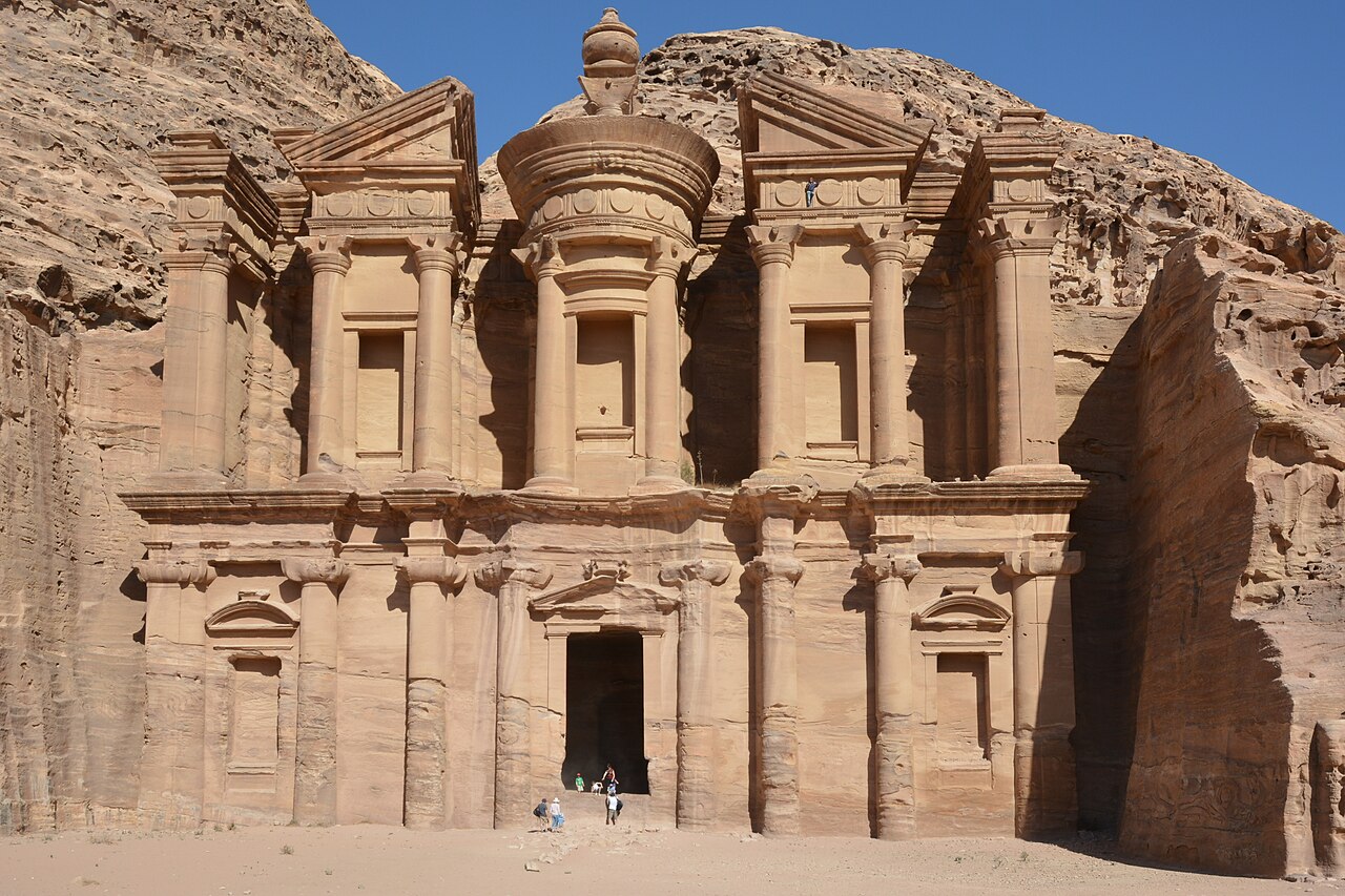
The Treasury measures approximately 40 metres tall by 25 metres wide and was carved in the 1st century BCE, most likely as the funerary monument of King Aretas IV, who ruled from 9 BCE to 40 CE. The interior consists of a single burial chamber with three niches and is entirely undecorated — the investment in the exterior facade was the architectural statement. Bedouin tradition held that an ancient pharaoh had hidden treasure inside the large urn at the top of the structure; the bullet marks still visible in the urn record attempts to release it. The name Treasury (Al-Khazneh, meaning “the chest”) derives from this tradition, not from any historical use of the building for storage.
Beyond the Treasury, the main valley opens into the Colonnaded Street, a 6-metre-wide paved road built during the Roman provincial period, flanked by column bases and the ruins of a monumental gateway. The Street of Facades borders the valley to the east, where more than 40 tomb facades are cut into the cliff at different heights. These were not built sequentially but represent an accumulation of individual commissions over several centuries, each family or civic group selecting a position and decorative scheme from Nabataean craftsmen who had absorbed Hellenistic, Egyptian, and Assyrian architectural conventions into a distinctive local style.
The Monastery (Ad Deir) stands at the far western edge of the site, reached by 800 steps carved into the rock — a climb of roughly 45 minutes from the valley floor. At 45 metres tall and 50 metres wide, it is larger than the Treasury. The structure was probably a Nabataean tomb that later served as a Christian church during the Byzantine period; cross carvings are visible inside the main chamber, and a stone altar remains in place. The surrounding plateau offers an unobstructed view across the Wadi Araba toward Israel and the distant silhouette of the Negev highlands.
The Hydraulic City: Engineering Water in an Arid Environment Throughout the site — visible at multiple points along walking routes
Petra’s survival in a desert environment with average annual rainfall below 150 mm depended entirely on an engineered water system. The Nabataeans built ceramic pipes, rock-cut channels, cisterns, and dams to collect flash-flood water from surrounding wadis and groundwater from springs. Archaeological estimates suggest the system supplied the city with approximately 40 million litres of water per day at its peak population of 20,000 to 30,000 inhabitants. Parts of this infrastructure are now partially reconstructed and visible along the walking routes.
The dam at the northern entrance of the Siq redirected flash-flood water away from the gorge to prevent it from flooding the main processional route — a practical engineering decision that also protected the carved niches and inscriptions along the walls. A second channel system, cut into the rock on the right-hand wall of the Siq, carried fresh water from Ain Musa (the Spring of Moses) into the city. At the far end of the site, near the Monastery, cisterns carved into the plateaus stored rainwater collected from broad surfaces during winter storms.
The hydraulic system was not merely utilitarian. The water channels fed a garden district in the central valley — excavations in the early 2000s at the Great Temple complex and adjacent areas revealed evidence of ornamental pools, garden plantings, and a small island structure, suggesting that the Nabataean elite invested in conspicuous water display as a signal of civic wealth. In a landscape where water is scarce, its controlled abundance was itself a form of architecture.
Roman annexation in 106 CE did not destroy Petra; the city continued as the capital of Provincia Arabia and received Roman-era additions including the Colonnaded Street, a bath complex, and modifications to the Temenos Gate. The real disruption came with trade route shifts: Palmyra in Syria emerged as a rival commercial centre, and Red Sea shipping routes increasingly bypassed overland caravan tracks through Petra. A catastrophic earthquake in 363 CE caused structural damage across the site. By the 7th century, Petra was largely depopulated. The city remained unknown to Western scholarship until Swiss explorer Johann Ludwig Burckhardt, travelling in disguise as a Muslim pilgrim under the Arabic name Ibrahim ibn Abdallah, entered the site in 1812 on the pretext of making a sacrifice at the tomb of Aaron on the mountain above.
Practical information
Petra is located 3 km from the town of Wadi Musa, which has hotels across all price categories. The main visitor centre is at the edge of town; the walk from the entrance gate to the Treasury takes approximately 30 minutes through the Siq. The site covers 264 km² in total, though most visitor routes concentrate on the central valley and the ridge paths to the High Place of Sacrifice and the Monastery. Plan a minimum of one full day for the core monuments; two days allow the Monastery climb and outlying tombs without rushing. Horses are available for the entrance path (included in the ticket for the first 800 metres); horse-drawn carriages run along the Colonnaded Street. Donkeys and mule rides are offered on the Monastery steps — these are optional and privately operated. Entry fees are set by the Jordan Tourism Board; a multi-day Petra Archaeological Park pass is significantly cheaper per day than a single-day ticket. The site is open year-round; summer temperatures in July and August regularly exceed 38°C, making early morning entry and the Petra by Night torchlight event (Monday, Wednesday, Thursday evenings) the most practical options. The nearest other UNESCO sites are Wadi Rum (100 km south via the Desert Highway) and Um er-Rasas (100 km northeast via the Kings Highway through Shobak).
Frequently Asked Questions
Why is Petra called the Rose-Red City?
The description comes from a sonnet by the English poet John William Burgon, written in 1845 — he called Petra “a rose-red city half as old as time.” Burgon never visited the site; he was working from published accounts by earlier travellers. The phrase became widely quoted, though archaeologists and travel writers tend to note that the sandstone cliffs around Petra display a much broader colour range than a single rose-red shade. The stone varies from pale cream and yellow to orange, deep burgundy, and purple depending on the mineral content of different rock strata and the angle of light. The Treasury, for instance, shifts from pale pink at midday to vivid amber and rust at sunrise and sunset. The geological formation responsible is the Nubian Sandstone, laid down in the Cretaceous period and later compressed and faulted into the highland plateau the Nabataeans chose as their capital. The colour variety was not incidental to Nabataean builders: the facades of some tombs deliberately exploit colour banding in the rock face as a decorative element, placing chambers at points where the natural striations create horizontal bands across the carved architecture. The phrase itself, whatever its poetic inaccuracy, has served as one of the most effective pieces of promotional writing in the history of archaeological tourism.
How did the Nabataeans control the trade routes, and what happened when Rome arrived?
The Nabataean kingdom established its commercial dominance by controlling the water sources along the overland routes carrying frankincense from southern Arabia (modern Yemen and Oman), myrrh, spices from India, and luxury goods moving toward Mediterranean ports. Their hydraulic engineering — applied not just in Petra but at way-stations across the Negev desert — made long desert crossings possible by guaranteeing water supply at predictable intervals. The Nabataean state collected tolls and offered protection; Greek and Roman sources note that Nabataean merchants were effective diplomats who deflected military expeditions, including a Roman expedition under Aelius Gallus in 25–24 BCE, by prolonging negotiations and denying invaders access to water. When Rome formally annexed Nabataea in 106 CE under the Emperor Trajan, the transition appears to have been largely peaceful — there is no evidence of military destruction at Petra from this period. The Romans renamed the territory Provincia Arabia Petraea, kept Petra as the provincial capital, and invested in urban infrastructure. The economic decline came later and gradually, driven by the rise of Palmyra as a competing trade hub and, after the 3rd century, by changes in Mediterranean demand for the spice and incense trade that the Nabataeans had supplied.
What is the Petra by Night experience and how does it differ from the daytime visit?
Petra by Night is a ticketed evening event held three times per week — currently Monday, Wednesday, and Thursday — beginning at 20:30 and lasting approximately two hours. Visitors walk the Siq in darkness lit by approximately 1,500 candles placed along the path at ground level; the effect is a slow procession through the gorge with minimal artificial lighting, arriving at the Treasury, which is illuminated from below by candles arranged across the sand in front of the facade. The event includes a short performance of traditional Bedouin music and a brief narration. The visit is confined to the Treasury forecourt; the rest of the site is not accessible during the evening event. It does not replace a daytime visit — the carved details of the facade are not clearly visible by candlelight, and the walk through the Siq is experienced very differently without the ability to read the carved niches and water channels visible in daylight. The appeal is atmospheric rather than educational: the Treasury at night, seen from the end of a dark gorge, provides a visual encounter with the site that daytime crowds and full sunlight cannot replicate. Tickets are purchased separately from the daytime entry pass. The walk involves the same 1.2 km Siq path in both directions on uneven stone; comfortable footwear is necessary.