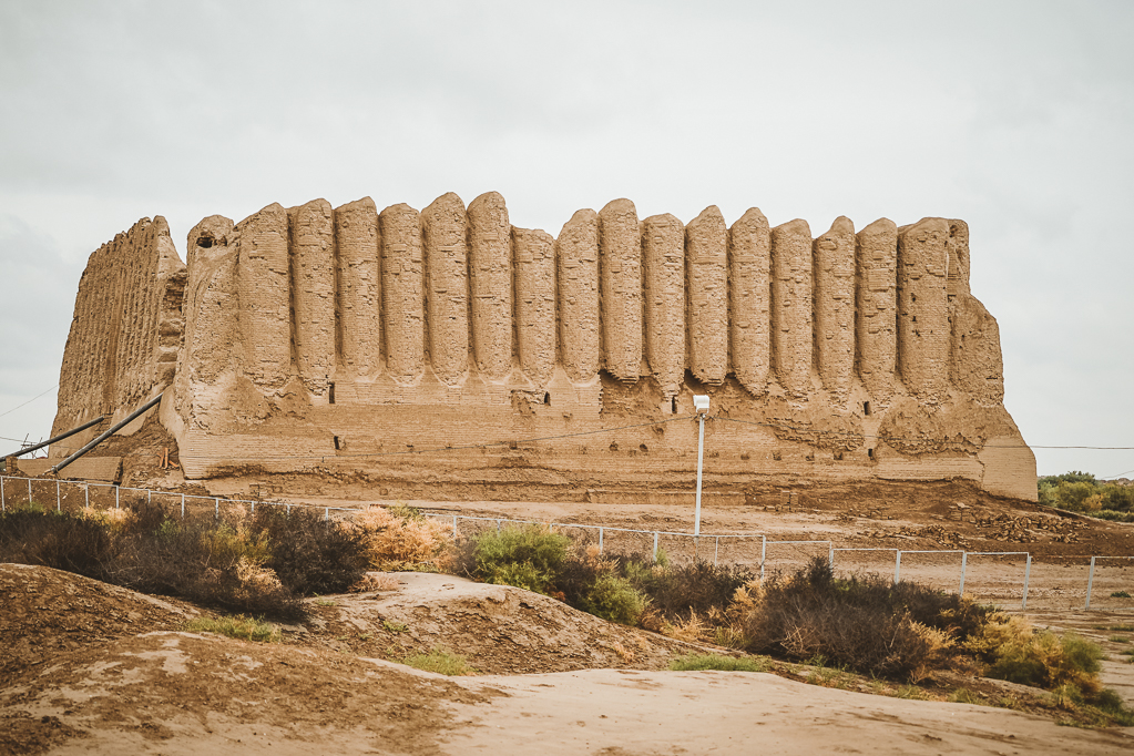
Ancient Merv, inscribed as a UNESCO World Heritage Site in 1999, is an archaeological complex covering approximately 200 km² in the Karakum Desert of modern Turkmenistan, near the city of Mary. The site contains the stratified remains of at least five distinct cities built successively on the same desert oasis over roughly 4,500 years. At its 12th-century peak under the Seljuk sultan Sanjar, Merv had an estimated population of 200,000 to one million people — figures that, if accurate, would make it the largest city on earth at that time — before Mongol forces killed the population and destroyed the irrigation infrastructure that had sustained the oasis for millennia.
Five cities on one oasis: the archaeological sequence from Erk Kala to Sultan Kala 30 km from Mary, Turkmenistan
The physical complexity of ancient Merv is unlike any other archaeological site in Central Asia. Visitors see not a single ruined city but a layered series of walled enclosures, each representing a distinct political and cultural era, spread across the desert floor in a sequence that can be followed on the ground.
Erk Kala is the oldest surviving enclosure, a roughly circular mud-brick citadel approximately 12 hectares in area. Archaeological evidence places its initial occupation in the Achaemenid period (6th–4th century BCE), and it was in active use when Alexander the Great passed through the region circa 329–328 BCE — the same campaign that brought him to Samarkand. The name Merv appears in Achaemenid inscriptions as Margu, one of the satrapies of the Persian Empire. Gyaur Kala, the next enclosure, is a large square walled city developed by the Parthian dynasty (from approximately the 3rd century BCE) and expanded by the Sassanid Persians; at its peak this city covered approximately 1,000 hectares, far larger than almost any contemporary city in the ancient world. Gyaur Kala preserves some of the largest surviving mud-brick fortification walls in the region, in places still reaching 8–10 metres in height.
Sultan Kala is the medieval Islamic city, begun under the Arab conquest (7th century CE) and brought to its greatest extent by the Great Seljuk sultanate in the 11th and 12th centuries. It is the largest of the five enclosures and the area that most visitors focus on. Abdullah Khan Kala (Timurid period, 15th–16th century) and Bairam Ali Khan Kala (18th century) are smaller and later, built when Merv was a secondary city attempting to rebuild after the catastrophic Mongol destruction.
The entire complex is accessible as a UNESCO World Heritage Site but requires a guide or self-navigation with a map, as the ruins are spread across desert terrain without paved paths between them. The Sultan Sanjar Mausoleum is the single standing monument that gives non-specialists an immediate sense of the site’s former scale.
The Seljuk city, the Sultan’s library, and the Mongol massacre of 1221 Sultan Kala section of the archaeological complex
The Great Seljuk sultanate made Merv one of its principal capitals in the 11th and 12th centuries. Sultan Sanjar (reigned 1118–1157), who ruled an empire stretching from Anatolia to the borders of China and northern India, chose Merv as his seat of government. Under his rule the city reached its demographic and cultural maximum. Medieval Islamic geographers and travellers describe it as a city of extraordinary richness: Yaqut al-Rumi, writing in the early 13th century shortly before the Mongol destruction, counted 12 public libraries in Merv — a number that, if accurate, would exceed the total book collections available in the whole of Western Europe at the same date. The royal library reportedly held 150,000 volumes. Yaqut spent three years in Merv using its libraries to research his geographical encyclopaedia.
The Mausoleum of Sultan Sanjar, built approximately 1157, is the most significant surviving structure at Merv and one of the largest intact medieval buildings in Central Asia. A square tower approximately 27 metres per side and 38 metres to the apex of the dome, it is constructed of fired brick and was originally surmounted by a turquoise-tiled dome visible, according to 12th-century accounts, from a journey of two days across the desert. The dome collapsed and has been partially reconstructed; the interior preserves the original pendentive and muqarnas decoration at the transition from the square base to the octagonal drum. The mausoleum stood at the centre of a large mosque complex, most of which no longer survives above ground.
In February 1221, the Mongol commander Tolui — youngest son of Genghis Khan — arrived at Merv with a substantial force. The city surrendered after a brief negotiation. Tolui ordered the population to assemble outside the walls. What followed is the most detailed recorded instance of deliberate Mongol urban annihilation: medieval sources including Juvayni give figures ranging from 700,000 to 1.3 million killed over several days. Modern historians regard these numbers as almost certainly exaggerated — the logistics of killing that many people in that time make the higher figures implausible — but the destruction of Merv was real and systematic. The qanat irrigation channels that had carried Murghab River water to the oasis for centuries were cut. Without irrigation, the agricultural base of the oasis collapsed. Merv was rebuilt on a smaller scale in the Timurid period, but never regained anything approaching its former population.
Practical information
Ancient Merv is reached from the city of Mary (also spelled Merv in older sources), which has a domestic airport with flights to Ashgabat, the Turkmenistan capital. The archaeological site lies approximately 30 km east of Mary city centre. Most visitors to Merv arrive as part of a guided tour organised in Ashgabat, as independent travel in Turkmenistan is subject to significant restrictions: the standard tourist visa (e-visa or letter of invitation) requires a government-approved guide and pre-registered itinerary. Transit visas permit a shorter independent visit along a set route.
Turkmenistan’s Ministry of Culture controls site access; the Mary Regional Museum in the city of Mary holds the principal collection of artefacts from the Merv excavations, including Sassanid silver, Seljuk ceramics, and architectural fragments. The museum visit is generally included in organised Merv tours and provides essential context for the mostly unexcavated ruins.
The site has no food or water vendors within the archaeological zone. Visits in summer (June–August) require serious heat preparation: temperatures in the Karakum Desert regularly exceed 45°C. Spring (March–May) and autumn (September–November) are the practical visiting windows. The nearest UNESCO World Heritage Site within Uzbekistan is the Itchan Kala in Khiva, approximately 400 km to the north via the Turkmenistan–Uzbekistan border; this crossing requires advance planning for visas and may have restricted hours.
Frequently Asked Questions
How do historians estimate the population of medieval Merv, and how reliable are figures suggesting it was the world’s largest city?
Estimating the population of pre-modern cities is methodologically difficult, and figures for medieval Merv vary more than for almost any other historic city. The claim that Merv had a population of 200,000 to one million at its 12th-century peak circulates widely; the range itself indicates the uncertainty. Historians use several indirect methods to estimate population: the area enclosed by city walls (Sultan Kala covers approximately 600 hectares of settled area, implying a substantial population at typical medieval densities), the number and capacity of documented structures (mosques, caravanserais, madrasahs), and contemporary literary descriptions. Yaqut al-Rumi’s early 13th-century account describes a city divided into four large administrative quarters, each with its own mosque, bazaar, and bath complex — a structure that implies a population in the hundreds of thousands. The figure of one million is at the optimistic end and is not universally accepted; 200,000–500,000 is the range most historians regard as plausible. For comparison, Constantinople — the largest city in medieval Europe — had an estimated 400,000 people at its Byzantine peak. Whether Merv exceeded it is genuinely uncertain. What is not in question is that Merv was one of the largest cities in the Islamic world and in the world as a whole for the period between approximately 1050 and 1221, and that its destruction by the Mongols was one of the most consequential demographic events of the medieval period.
What remains of the Sultan Sanjar Mausoleum today, and how does it compare to its original state?
The Sultan Sanjar Mausoleum survives in substantially intact form from the square base through the transition zone to the drum. The outer dome, which medieval travellers described as visible across the desert for two days’ journey — suggesting a turquoise-tiled exterior on a high drum — collapsed at some point between the 13th and 19th centuries and has been partially reconstructed using a combination of original materials recovered on site and new brick. The reconstruction is not universally praised: the rebuilt dome is geometrically approximate rather than a precise replica of the original form, which is not documented with enough precision to enable faithful replication. The interior of the mausoleum preserves the original muqarnas (stalactite vaulting) decoration at the pendentive level — the transition zone from the square base to the circular drum — in a condition that gives a reliable sense of the Seljuk decorative programme. The interior walls were originally plastered and painted; little of this survives. The grave of Sultan Sanjar himself is indicated by a marker inside the mausoleum, though whether his actual remains are present after the 1221 Mongol assault is unknown. The building is the subject of ongoing conservation work funded by a combination of the Turkmenistan government and international organisations; access is through the designated opening in the west wall under supervision.
Why did the Mongol destruction of Merv’s irrigation system have more lasting consequences than the killing of its population?
Merv existed because of irrigation. The Murghab River descends from the mountains of modern Afghanistan and disperses into the Karakum Desert in the Merv oasis, where without human management the water simply sinks into the sand. Over several thousand years, successive populations at Merv constructed an elaborate system of canals, qanats (underground channels), and distribution networks that spread the river water across a large agricultural zone. This infrastructure supported a large urban population in a desert environment where rainfall is minimal and insufficient for rain-fed agriculture. When Tolui’s forces systematically cut the main canals in 1221, the destruction was not merely of the existing crops and population but of the physical infrastructure that made the oasis viable. Rebuilding qanat networks requires labour, engineering knowledge, social organisation, and political stability — none of which existed in the immediate aftermath of the Mongol conquest. The Timurid rebuilding of Merv in the 15th century restored a fraction of the irrigation capacity, supporting a much smaller population. The full-scale qanat system was never restored; modern Mary relies on a different water management regime serving an entirely different urban economy. The contrast between Merv and Bukhara or Samarkand, which were also attacked by the Mongols but not subjected to the same systematic destruction of agricultural infrastructure, illustrates why the former never recovered while the latter did.