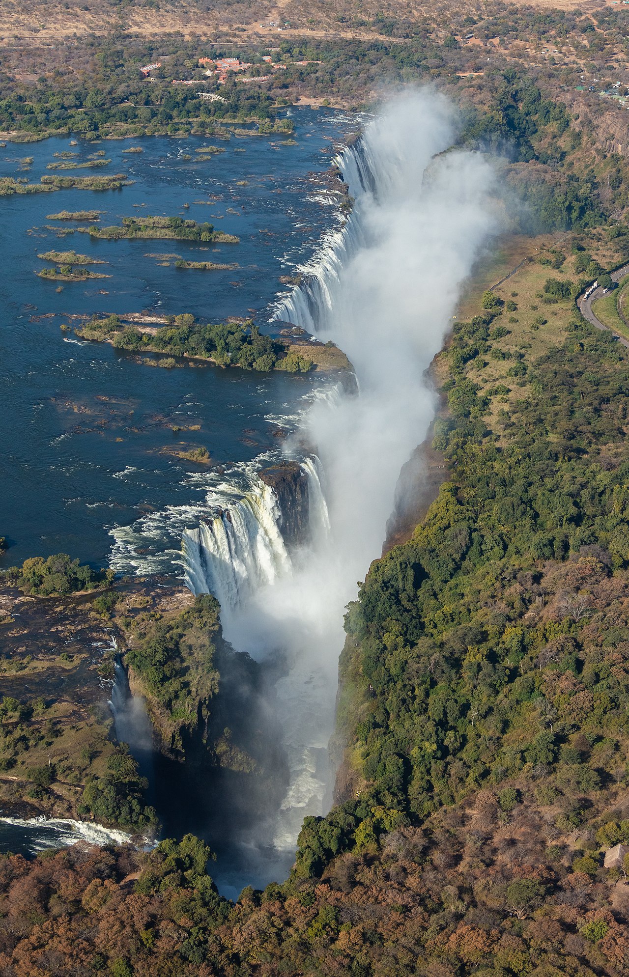
Mosi-oa-Tunya — “The Smoke That Thunders” in the Kololo language — announces its presence from 50 kilometres away as a rising column of spray visible against the flat savanna horizon long before any sound is heard. Inscribed on the UNESCO World Heritage List in 1989 under a dual name acknowledging both its African identity and its colonial designation, Victoria Falls spans the full width of the Zambezi River at a point where the river drops 108 metres into a narrow basalt gorge, creating the largest waterfall on earth by the combined measure of height and width. The site straddles the border between Zambia and Zimbabwe, with different viewing angles, activities, and crossing points on each side.
Geology, scale, and the mechanics of the world’s largest waterfall Zambia / Zimbabwe border on the Zambezi River
Victoria Falls is a geologically young feature by the standards of landscape formation — a product of the Zambezi River’s ongoing erosion of a basalt plateau laid down approximately 150 million years ago during the Karoo volcanic episode. The plateau is fractured by a series of east-west fault lines running roughly parallel to each other. The Zambezi, flowing east across the plateau, has successively exploited these fractures: each time the river carved down to the bottom of one gorge, erosion worked headward (upstream) along the fracture until the waterfall abruptly retreated to the next parallel fracture further upstream. The result is a sequence of eight zigzag gorges below the current falls, each representing a previous waterfall position. The falls are moving south — upstream relative to the river’s flow — at an estimated rate of 3 to 5 centimetres per year, meaning that in geological time the current spectacle is a recent and temporary feature of the landscape.
The numbers that define Victoria Falls are straightforward and striking. The falls are 108 metres high (Niagara Falls, by comparison, is 57 metres at its Horseshoe section). The falls are 1,708 metres wide — the full width of the Zambezi at this point — making them significantly wider than Iguazú Falls in South America (approximately 1,491 metres at its widest). No other waterfall matches both dimensions simultaneously: nothing as high as Victoria Falls is as wide, and nothing as wide is as high. At peak flow, during the Zambezi’s flood season from February through May, the volume of water passing over the lip reaches approximately 500 million litres per minute. At this stage the spray cloud rises 400 metres into the air and the roar is audible for over 40 kilometres. The visual effect from the Zimbabwean viewpoint — where the full 1,708-metre curtain of white water is visible across the chasm — is one of the most kinetically overwhelming natural spectacles accessible to visitors anywhere in the world.
The geology also produces the famous Rainbow Pool and the Devil’s Pool, a natural rock basin that forms on the Zambian side at the very lip of the falls during the dry season. A submerged rock ledge creates a slight barrier that holds the pool’s water back from the main drop, and during low-flow months (August through January) guides swim visitors across from Livingstone Island to the pool’s edge, where it is possible to look directly over the 108-metre drop into the first gorge below. The ledge is real, the experience is technically managed, and the risk calculus is contested — the pool has occasionally been the site of accidents — but it persists as one of the most vertiginous natural swimming experiences on earth.
David Livingstone, the Victoria Falls Bridge, and the two-country experience Zimbabwe viewpoint / Zambian Knife-Edge / Victoria Falls Bridge
David Livingstone (1813–1873), the Scottish missionary and explorer sponsored by the London Missionary Society and later by the Royal Geographical Society, reached the falls on 16 November 1855 — the first European to see them, travelling by dugout canoe with Kololo guides from the nearby village of Sesheke. His account, published in “Missionary Travels and Researches in South Africa” (1857), introduced the falls to European audiences and established the name “Victoria Falls” in the British convention of honouring the monarch. Livingstone himself expressed discomfort at this naming practice in his journals, noting that the site already had a perfectly good name in local use. The Kololo-language name “Mosi-oa-Tunya” — now formally recognised in the dual UNESCO inscription — was the name used by the communities of the Lozi people who had lived alongside the Zambezi for generations before European exploration reached the interior of southern Africa.
Livingstone’s statue stands on the Zimbabwean side of the falls, near the main viewpoint path. The path itself, “The Rain Forest Walk,” runs along the lip of the gorge opposite the falls for approximately 1.5 kilometres, offering a sequence of viewpoints through the mist-drenched vegetation — some 420 plant species concentrate in this perpetually wet microclimate, a lush anomaly in the surrounding dry savanna. The path can be thoroughly soaking at peak flow in March and April, when the spray is so dense that waterproof clothing and lens covers are needed for photography. At low water in October and November, the same path offers clear sightlines to the full rock face and the gorge below.
The Victoria Falls Bridge, completed in 1905 to a design by the engineer George Hobson for Cecil Rhodes’s Cape-to-Cairo railway project, crosses the second gorge at a height of 111 metres above the Zambezi. Rhodes died before the bridge was completed; his vision of a continuous British rail corridor from South Africa to Egypt was never realised. The bridge today is the border crossing between Zimbabwe and Zambia and is the site of the world’s most celebrated bungee jumping operation — the 111-metre freefall places jumpers momentarily in the mist cloud of the falls at the bottom of their arc. Bridge tours and zip-line crossings are available separately. The crossing between the two countries is straightforward for most nationalities, allowing visitors to experience the falls from both banks in a single day: the Zimbabwean side for the panoramic view across the full width, the Zambian side for the Knife-Edge Bridge (a suspension footbridge over the gorge with the full face of the falls visible), the Boiling Pot (a river pool at the confluence of the first and second gorges), and access to Livingstone Island and the Devil’s Pool.
Practical information
Victoria Falls town (Zimbabwe) and Livingstone (Zambia) are the two gateway towns, separated by the bridge. Both have international airports: Victoria Falls Airport (VFA, Zimbabwe) receives direct flights from Johannesburg (approximately 1 hour 30 minutes), Cape Town, and some European charter services. Livingstone Airport (LVI, Zambia) is served primarily from Lusaka (approximately 1 hour) and Johannesburg. Most visitors arrive from Johannesburg, which is the main regional hub. Victoria Falls is accessible year-round; the optimal visiting period depends on priorities. February–May offers maximum water volume but heavy spray obscures views and photography. June–September offers the best balance of water volume, clear views, and dry-season wildlife in adjacent Chobe National Park (Botswana, a short drive from Kasane). October–January is the dry season — the falls are lower (up to half the lip may be exposed rock on the Zimbabwean side) but visibility is exceptional and the Devil’s Pool is accessible. Entry fees are charged separately by Zimbabwe and Zambia; a KAZA UniVisa covers both countries for most nationalities. A minimum of one full day is recommended; most visitors spend two to three days to combine both sides with wildlife activities.
Frequently Asked Questions
What is the best time of year to visit Victoria Falls, and how does flow volume affect the experience?
The question of when to visit Victoria Falls has no single correct answer because the falls change dramatically through the year, and the “best” version depends on what a visitor prioritises. The Zambezi’s flood season peaks in February through April, when the river’s flow is at maximum — the spray column rises 400 metres, the roar is audible from Livingstone and Victoria Falls towns, and the rainbow arc is almost always present in the mist. This is the most powerful version of the falls, but the spray is so dense that close viewpoints are nearly invisible and photography is difficult without weatherproof equipment. May through July represents the transition from high to moderate flow: the spray is still dramatic, the full 1,708-metre curtain is active, and conditions allow both viewing and photography. August through October is the dry season — water volume drops significantly, exposing rock face on the Zimbabwean side and making some viewpoints on that bank relatively underwhelming. However, the Zambian side retains flow through the dry season, the Knife-Edge Bridge viewpoint is clear, and the low water opens the Devil’s Pool to swimmers (typically August through January). The dry season also coincides with the best wildlife viewing season in adjacent reserves, making it the most popular overall period for combining heritage and safari. November to January is the hottest period and the pre-flood low; water is at its minimum. Visiting outside these extremes — May–June or September — gives the most balanced experience.
How does the Victoria Falls Bridge bungee jump work, and is it the only adventure activity available?
The Victoria Falls Bridge bungee jump is operated by African Extreme and is widely considered one of the world’s premier bungee experiences, not primarily for its height (111 metres) but for its setting: jumpers fall from the bridge into the mist cloud of the falls, with the churning Zambezi gorge below and the spray of the falls visible on the lateral peripheral. The jump is a standard natural-rubber bungee operation with ankle harness; the full freefall takes approximately 4–5 seconds before the cord begins to decelerate. Bridge tours, which allow pedestrian access onto the bridge structure and into the central walkway, are also available for those who want the views without the jump. Beyond bungee, the falls area offers a significant range of activities: white-water rafting on the Zambezi below the falls (through the gorge series, Grade 4–5 rapids, best during low water when the gorge is accessible — September to December); helicopter flights over the falls (15–30 minutes, offering a perspective impossible from ground level and highly recommended for photography); guided canoe safaris on the upper Zambezi above the falls (flat water, wildlife-adjacent, completely different experience from the gorge); sunset cruises on the upper Zambezi; and Livingstone Island tours with Devil’s Pool access (Zambian side, dry season). The town of Livingstone, Zambia, also has a dedicated railway museum and the Livingstone Museum (covering the explorer’s life and regional archaeology), for visitors who want to spend a second or third day on cultural activities.
How did the falls acquire both their names, and what is the cultural significance of “Mosi-oa-Tunya” to local communities?
The Kololo-language name “Mosi-oa-Tunya” predates European contact with the falls by generations. The Kololo were originally a Sotho-speaking group from what is now South Africa who migrated north in the early 19th century and briefly dominated the Lozi people of the upper Zambezi before being absorbed or expelled in the 1860s; their language, however, left lasting traces in the regional vocabulary, and “Mosi-oa-Tunya” remained the name used by communities on both banks of the Zambezi who oriented their lives — fishing, trading, ritual — around the river and the falls. The name is descriptive rather than mythological: it refers directly to the sensory experience of the place, the column of smoke-like mist rising from the thunder of falling water. David Livingstone’s choice to name the falls for Queen Victoria was consistent with the practice of his era’s explorers, who understood themselves to be “discovering” and naming features for European geographic knowledge, regardless of existing names. The dual UNESCO inscription (1989) formally recognises “Mosi-oa-Tunya” as the Zambian designation and “Victoria Falls” as the Zimbabwean, both applying to the same site. In practice, signage and usage in Zambia now predominantly uses “Mosi-oa-Tunya” in official contexts, while “Victoria Falls” remains the internationally dominant name and the name of the Zimbabwean town. The Lozi people continue to hold annual ceremonies on the Zambezi (the Kuomboka, celebrating the flooding season) that reflect the long relationship between the river’s rhythms and the communities of its floodplain.