The Ruins of Loropéni in southwestern Burkina Faso are the only UNESCO World Heritage Site in the country and the best-preserved example of some 100 laterite stone enclosures built across the Lobi region between approximately 1000 and 1400 CE. The enclosures were likely associated with the trans-Saharan gold trade that made the West African savannah one of the most economically significant regions in the medieval world — and were already abandoned when the first European visitors arrived in the late nineteenth century.
The laterite enclosures and the gold trade Poni Province, southwestern Burkina Faso
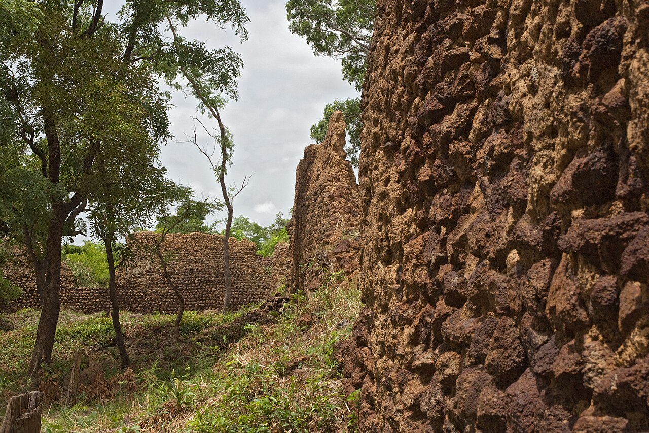
Loropéni sits in the Poni Province of southwestern Burkina Faso, near the convergence of three national borders: Burkina Faso, Ghana to the south, and Côte d’Ivoire to the southwest. The site lies in a transitional zone between savannah and the denser vegetation of the Guinea zone, an area of rivers, laterite plateaux, and alluvial plains that historically produced significant quantities of gold. The ruins themselves consist of a main enclosure — roughly 100 by 100 metres — and several associated secondary enclosures, all constructed from locally quarried laterite stone fitted without mortar.
Laterite is a reddish iron-rich rock formed by intense tropical weathering that strips away soluble minerals and leaves a residue of iron and aluminium oxides. It is abundant across the West African savannah belt and, where it outcrops in thick layers, can be quarried into usable building blocks. At Loropéni, the builders shaped laterite slabs into courses of roughly rectangular blocks and stacked them to heights of up to 6 metres, with walls reaching 1.4 metres in thickness at their base. The absence of mortar means the structures depend entirely on the weight and fit of individual blocks for their integrity — a technique that has proven durable enough to leave walls standing after six centuries of abandonment and vegetation encroachment.
The purpose of the enclosures has been debated since they were first documented by European researchers. The dominant interpretation, supported by the enclosures’ positions controlling river crossings and road junctions in a gold-producing region, links them to the trans-Saharan gold trade. From roughly the eighth to the sixteenth centuries CE, gold mined and alluvially panned in the West African savannah moved north across the Sahara to North African markets, then on to the Mediterranean and beyond. This trade was the economic foundation of a succession of West African empires — Ghana, Mali, Songhai — and made cities such as Timbuktu and Djenné into major centres of commercial and intellectual life. The Lobi region was among the most productive gold sources in this system. The enclosures at Loropéni and across the wider Lobi landscape are interpreted as fortified settlements built by communities controlling and taxing the movement of gold along these routes.
The precise identity of the builders remains uncertain. Archaeological and oral historical evidence points to the Lobi people or their precursors, and Lobi oral tradition names the builders as the Ngan — a pre-Lobi group that either was absorbed into the Lobi or retreated from the region as Lobi settlement expanded. When the gold trade contracted — possibly due to shifts in trans-Saharan routes, the rise of competing sources, or political disruption in the northern markets — the economic rationale for the enclosures disappeared. Loropéni was deserted well before the nineteenth century. When French colonial forces reached the area in the 1890s, local communities identified the ruins as the work of predecessors, not as inhabited settlements.
Burkina Faso’s sole UNESCO site in its broader context Poni Province, southwestern Burkina Faso
Loropéni was inscribed on the UNESCO World Heritage List in 2009, becoming Burkina Faso’s first and, as of 2024, only World Heritage property. The inscription was the result of sustained advocacy by the Burkinabè government and international archaeologists who argued that the Lobi stone enclosures represented an under-recognized category of monumental architecture in sub-Saharan Africa — construction traditions that paralleled the better-known stone enclosures of Great Zimbabwe but developed independently and in different ecological and economic contexts.
The wider significance of the inscription lies partly in what it corrects. Medieval West African architecture has been systematically undervalued in global heritage narratives that privilege stone buildings in temperate climates over the earthen and laterite construction of the tropics. The mud-brick mosques of the Mali Empire, the laterite enclosures of the Lobi region, and the earthen palaces of Dahomey represent monumental building traditions of equivalent ambition to the medieval cathedrals of Europe — but they have proven less legible to heritage systems inherited from European colonial scholarship.
Burkina Faso itself carries a name that reflects the revolutionary politics of its recent history. The country was known as Upper Volta — after the three Volta rivers (Black, White, and Red) that drain its territory — from independence in 1960 until 1984, when the military leader Thomas Sankara renamed it. “Burkina” derives from Mooré (the language of the Mossi, the country’s most numerous ethnic group) and means “upright” or “dignified”; “Faso” derives from Dioula and means “homeland” or “father’s house.” The name thus translates roughly as “Land of Incorruptible People” — a direct rebuke to the corruption Sankara’s revolutionary government claimed to be combating. Sankara himself was assassinated in 1987, but the country retained the name he gave it.
Contemporary access to Loropéni is complicated by security conditions in Burkina Faso. Since approximately 2015, the country has experienced a severe jihadist insurgency spreading from Mali, which has destabilized large areas of the north, east, and increasingly the southwest — the region where Loropéni is located. As of the date of this article, numerous Western governments classify Burkina Faso’s southwestern provinces, including Poni Province, as areas where travel should be avoided or undertaken only with specialist advice and security arrangements. Conditions on the ground change rapidly; any visitor considering a trip to Loropéni must consult current official travel advisories from their own government and from the Burkinabè Ministry of Tourism before making plans.
Practical information
Loropéni is located in the Poni Province of southwestern Burkina Faso, approximately 30 kilometres from the town of Gaoua (the provincial capital) and roughly 400 kilometres southwest of Ouagadougou, the national capital. Under normal security conditions, the site can be reached by road from Gaoua in under an hour; the road south from Gaoua toward the Ghanaian border passes near the site. The nearest commercial airport with international connections is Ouagadougou (OUA); under normal conditions, road travel from Ouagadougou to Gaoua takes approximately eight hours. As of 2024, Burkina Faso’s security situation in the southwest is severely compromised by the Sahelian jihadist insurgency. Check current travel advisories from your government (UK FCDO, US State Department, French MEAE, or equivalent) before any planning. Academic researchers and heritage professionals visiting the site typically coordinate with the Institut du Patrimoine Culturel (IPC-BF) in Ouagadougou and arrange security escorts through official channels. No tourist infrastructure exists at the site itself; Gaoua has basic accommodation. Entry to the site is managed by local community guardians. The Musée de Gaoua (Musée des Peuples du Sud-Ouest) in Gaoua provides essential context for the archaeology and ethnography of the Lobi region and is worth visiting before proceeding to the site itself.
Frequently Asked Questions
Who built the Loropéni enclosures, and why were they abandoned?
The builders of the Loropéni enclosures are not definitively identified in the archaeological or historical record. The most widely accepted interpretation attributes them to the Lobi people or their direct precursors, who have inhabited the Poni Province and the adjacent areas of Ghana and Côte d’Ivoire for centuries. Lobi oral tradition names the actual builders as the Ngan — a group that preceded the Lobi in the region — and describes the enclosures as inherited rather than constructed by the Lobi themselves. Whether the Ngan were a distinct ethnic group absorbed by or displaced by the Lobi, or whether “Ngan” refers to an ancestral proto-Lobi population, is debated by historians and anthropologists working in the region. What is better established is the economic context: the Lobi region was a significant source of alluvial gold during the period when the trans-Saharan trade was at its height, roughly the eighth to the sixteenth centuries CE, and the enclosures’ positions along river crossings and trade routes are consistent with settlements built to control and profit from the movement of gold. When the gold trade contracted — for reasons that likely included depletion of accessible alluvial deposits, shifts in Saharan caravan routes, and disruption of the North African markets that consumed West African gold — the economic basis for maintaining fortified trading settlements disappeared. The enclosures were abandoned in stages, with Loropéni already deserted by the time French colonial forces documented it in the 1890s.
How do the Loropéni enclosures compare to Great Zimbabwe?
The Loropéni enclosures and Great Zimbabwe are the two most prominent examples of dry-stone enclosure construction in sub-Saharan Africa, and they invite comparison precisely because they developed independently, in different parts of the continent, during overlapping periods, for apparently similar economic reasons. Great Zimbabwe — UNESCO-inscribed in 1986 — is a much larger complex, with its Great Enclosure measuring roughly 250 metres in diameter and its walls reaching 11 metres in height. It served as the capital of the Zimbabwe Kingdom and was at the centre of a gold and ivory trading network linking the interior of southern Africa to the Swahili coast and from there to the Indian Ocean trade. Loropéni, by contrast, is one of approximately 100 smaller enclosures distributed across the Lobi region; it is the largest and best preserved of this group but does not approach Great Zimbabwe in scale or architectural elaboration. The building materials differ: Great Zimbabwe uses granite blocks fitted in careful courses; Loropéni uses laterite slabs. The key parallel is functional — both represent monumental stone construction by African polities whose economic power derived from controlling access to gold, and both were abandoned when the political and trade systems that sustained them collapsed. The parallel undermines any claim that monumental dry-stone construction in sub-Saharan Africa was exceptional or anomalous; it was, instead, a recurrent response to similar conditions of wealth, political consolidation, and the need to project power through architecture.
What is the current security situation in Burkina Faso, and can tourists still visit Loropéni?
As of 2024–2025, Burkina Faso is experiencing one of the most severe security crises in its post-independence history, driven by a jihadist insurgency that spread from Mali after 2012 and has progressively destabilized the country’s north, east, and, more recently, southwest. The Poni Province, where Loropéni is located, is in the southwestern region that security analysts classify as increasingly affected by armed group activity. Multiple Western governments — including the United Kingdom, the United States, France, and Germany — advise against all but essential travel to large parts of Burkina Faso, with some advisories recommending against all travel to the entire country. Attacks on roads, markets, and government facilities have occurred in areas that previously seemed insulated from the insurgency. Under these conditions, independent tourist visits to Loropéni are not advisable without specialist security advice and, in practice, not feasible through normal tourism channels. Academic and heritage researchers who need access to the site typically arrange visits through Burkinabè government institutions and accept significant constraints on movement. The situation is fluid: conditions that apply in 2024 may differ by the time you read this article. Check the most current advisories from your own government and from the Burkinabè Ministry of Tourism, and consider whether the heritage value of the visit can be adequately served by other means — including the Musée de Gaoua’s collections — until the security situation stabilizes.