
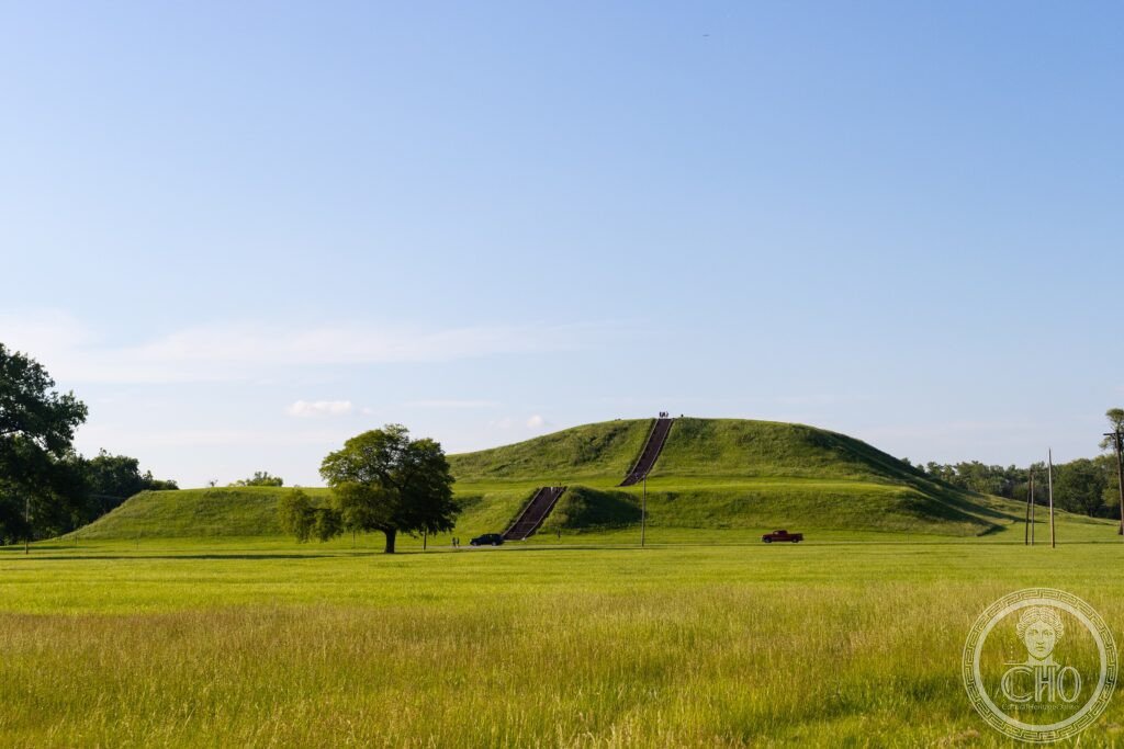
Cahokia Mounds preserves the largest pre-Columbian city north of Mexico, a metropolis of platform mounds and planned plazas that at its peak held more people than contemporary London. Its centrepiece, Monks Mound, covers a footprint larger than the base of the Great Pyramid of Giza. The city was abandoned before Europeans arrived, and no single explanation for its collapse has been agreed.
At a glance
Cahokia sits on the Mississippi floodplain opposite modern St. Louis and was the principal centre of the Mississippian culture, a society built on maize agriculture, platform mound construction, long-distance trade and hereditary chiefs. At its height the city covered a wide area of the floodplain, organised around a central plaza flanked by mounds and enclosed in part by a palisade.
The population is estimated to have reached its peak in the early twelfth century, when Cahokia is thought to have been larger than London at the same date. The city was gradually abandoned in the following centuries, long before any European set foot in the region, and the reasons for its decline remain a matter of debate among archaeologists.
Key facts
- Location: Collinsville, Illinois, on the Mississippi floodplain near St. Louis, Missouri
- Culture: Mississippian culture, active from roughly the ninth to the fourteenth century, peaking around 1050–1100 CE
- Scale: around 120 earthen mounds were built, of which some 80 survive today across the site
- Population: estimated at 10,000 to 20,000 at its peak, said to have exceeded contemporary London
- Monks Mound: base measuring 316 by 241 metres, larger in footprint than the base of the Great Pyramid of Giza, rising to 30.5 metres
- Recognition: inscribed as a UNESCO World Heritage Site in 1982
History
Cahokia grew into the largest and most complex urban centre in pre-Columbian North America north of Mexico, its economy tied to a long-distance exchange network that brought copper from the Great Lakes, marine shell from the Gulf Coast, chert from the Ozarks, mica from North Carolina and obsidian from the Rocky Mountains. The city’s central plaza and its ring of mounds formed the ceremonial and political heart of a wider Mississippian world.
The city was progressively abandoned between roughly 1300 and 1400 CE, well before European contact. Archaeologists have proposed several explanations, including a shift in climate that reduced maize yields on the floodplain, environmental degradation from the deforestation needed to build and fuel the mounds, the breakdown of the hereditary elite, disease, and warfare, evidenced by a palisade that was rebuilt more than once. No single account has been generally accepted.
Excavations between 2015 and 2020 by the University of Illinois at a site known as the Emerald Acropolis, some 25 kilometres northeast of Cahokia, revealed a subsidiary mound complex used seasonally rather than as a permanent settlement, with mound alignments corresponding to solar events and evidence of large-scale feasting. The find has widened the picture of Cahokia from a single urban core to the centre of a religious landscape reaching far beyond the city itself.
What you see
Monks Mound dominates the site: a four-terraced earthwork built from an estimated 614,000 cubic metres of earth carried basket by basket over roughly two and a half centuries, and named after the Trappist monks who farmed its southern terrace in the early 1800s. Its summit once carried a large timber structure, thought to have served as the residence or ceremonial centre of Cahokia’s ruling chief, and a paved footpath with some 156 steps now leads visitors to the top, from where the Mississippi River and the St. Louis skyline are visible to the west.
Nearby stands a reconstruction of Woodhenge, a series of circular arrangements of large red cedar posts first identified by archaeologist Warren Wittry in the 1960s. The posts were aligned to mark sunrise on the solstices and equinoxes, and the site still draws visitors at dawn on the spring and autumn equinoxes to watch the alignment repeat.
Mound 72, a low ridge mound excavated in the 1960s, contained one of the most striking burials found anywhere in eastern North America: a man laid on a platform of some 20,000 marine shell beads arranged in the shape of a bird, surrounded by further burials including an estimated 250 sacrificial victims, mostly young women, along with caches of arrowheads, mica and copper. The Cahokia Mounds Interpretive Center, funded by the state, sets all of this in context with models, dioramas and artefact displays, including a scale model of the city at its peak.
Practical information
- Admission: entry to the site is free; the Interpretive Center welcomes donations. Check the official Cahokia Mounds State Historic Site channels for current arrangements.
- Opening: the site is open daily apart from major public holidays; confirm hours with the official site before visiting.
- Time needed: the Interpretive Center and Monks Mound together take a couple of hours; walking the wider 890-hectare site takes closer to half a day.
- Weather: summers on the exposed mounds can be very hot, so visitors are advised to carry water.
Getting there
Cahokia Mounds lies in Collinsville, Illinois, a short distance east of St. Louis, Missouri, and close to Lambert-St. Louis International Airport. It is reachable by car from downtown St. Louis via the interstate in around twenty minutes. There is no direct public transport link from St. Louis; the nearest light rail station is a few kilometres from the site.
Nearby
- Gateway Arch National Park — a short distance west, in downtown St. Louis; Eero Saarinen’s stainless steel catenary arch, completed in 1965, houses the Museum of Westward Expansion and has been a National Park unit since 2018
- Fort de Chartres State Historic Site — around 80 kilometres south; an eighteenth-century French colonial stone fort on the Mississippi, built between 1753 and 1756 and taken by the British in 1765 after the Seven Years War
Sources
- Wikipedia, Cahokia
- Cahokia Mounds State Historic Site
- UNESCO, Cahokia Mounds State Historic Site (World Heritage Site reference 198)
Find it on the map
See this place and what’s around it →📷 Become a Cultural Heritage Online photographer
Share your photos of places: they stay published under your name as the author. The more they're seen, the more you get noticed — and soon a contest will reward the most appreciated photos.
Log in or sign up free to add a photo