


A vast desert landscape of sculpted sandstone cliffs, plateaus, and canyons spanning nearly 294,000 acres along Arizona’s northern border.
At a glance
Vermilion Cliffs National Monument encompasses the Paria Plateau, Vermilion Cliffs, Coyote Buttes, and Paria Canyon in extreme northern Arizona. The 293,689-acre preserve rises from 3,100 to 6,500 feet in elevation, protecting a remote and dramatically eroded landscape shaped by millions of years of geological forces.
History
President Bill Clinton established the monument by presidential proclamation on November 9, 2000, designating existing federally managed lands in Coconino County as protected terrain. The U.S. Bureau of Land Management, part of the Department of the Interior, now administers the site.
What you see
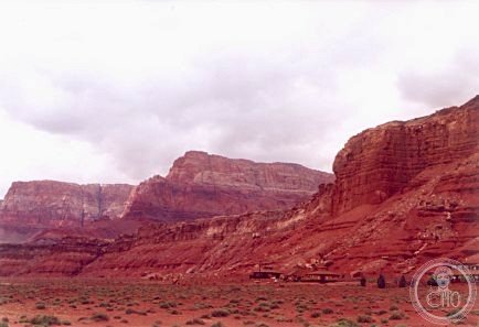
The Vermilion Cliffs themselves form steep escarpments of sandstone, siltstone, limestone, and shale that rise as much as 3,000 feet above their bases. Deep erosion has exposed hundreds of layers of richly colored rock strata. Mesas, buttes, and large tablelands alternate with steep canyons; small streams support sparse wildlife in this arid terrain. The Paria Plateau extends northward from the cliff tops as a flat expanse.
Cultural significance
The monument preserves one of the Colorado Plateau’s most visually striking geological formations, where exposed sedimentary layers record millions of years of environmental change. The area’s remote canyons and plateaus remain largely wild, offering insight into the region’s natural processes and desert ecology.
Key facts
- Location: Marble Canyon, Arizona 86036
- Coordinates: 37.7481282, −106.1505455
- Area: 293,689 acres (118,852 hectares)
- Elevation range: 3,100–6,500 feet
- Administrator: U.S. Bureau of Land Management
- Official website: blm.gov
Practical information
The monument’s remote location and challenging terrain require careful planning. Check the Bureau of Land Management website for current conditions, access restrictions, and permit requirements before visiting. Water and services are extremely limited in the area.
Getting there
Vermilion Cliffs lies in extreme northern Arizona, immediately south of the Utah border. The nearest town is Marble Canyon. You will need a vehicle suitable for backcountry travel and detailed maps to explore most of the monument safely.
See the place
Sources & resources
Gallery
Find it on the map
See this place and what’s around it →📷 Become a Cultural Heritage Online photographer
Share your photos of places: they stay published under your name as the author. The more they're seen, the more you get noticed — and soon a contest will reward the most appreciated photos.
Log in or sign up free to add a photo