
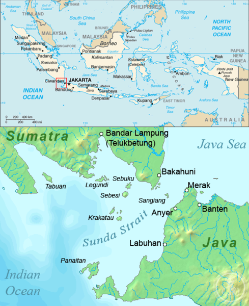
The largest island in the Sunda Strait between Java and Sumatra, Panaitan is a volcanic island of rugged beauty and natural significance. Once the private domain of Javan princes, it remains a frontier landscape shaped by geology and human presence.
At a glance
Panaitan covers approximately 170 square kilometers and rises to 1,450 meters. Located near Java Head, the westernmost tip of Java, it dominates the Sunda Strait’s geography. The island is volcanic in origin, though no historic eruptions are recorded.
History
The island’s name derives from its historical status as property of Javan princes—”Prinsen” or “Prince’s Island” in Dutch colonial nomenclature. When Krakatoa erupted catastrophically in 1883, Panaitan’s northern and eastern coasts were struck by tsunamis, but the island suffered far less damage than surrounding areas. Approximately 55 bodies were recovered, including a hajji authorized to harvest timber and roughly 50 squatters living on the island.
What you see
Panaitan’s landscape is defined by its volcanic terrain and dense tropical vegetation. The island rises steeply from the sea, presenting dramatic coastal cliffs and a rugged interior dominated by primary forest.
Cultural significance
The island holds ecological and cultural weight as part of Ujung Kulon National Park, one of Indonesia’s most important protected areas. It is renowned internationally for world-class surfing waves accessible to adventurous visitors seeking remote breaks.
Key facts
- Country: Indonesia
- Province: Banten
- Administrative division: Pandeglang Regency
- Area: Approximately 170 square kilometers
- Highest point: 1,450 meters
- Coordinates: -6.57528, 105.21
- Status: Part of Ujung Kulon National Park
Practical information & getting there
Panaitan is accessible from western Java and the Sunda Strait region. As part of Ujung Kulon National Park, visitor access is regulated to protect its ecosystems. Check with park authorities for current conditions, permits, and authorized routes before planning your visit.
Sources & resources
Find it on the map
See this place and what’s around it →📷 Become a Cultural Heritage Online photographer
Share your photos of places: they stay published under your name as the author. The more they're seen, the more you get noticed — and soon a contest will reward the most appreciated photos.
Log in or sign up free to add a photoIs this page about you?
This page is read by travellers and heritage enthusiasts who find it on Google. Tell us how you are connected to this place and we will take it from there.