
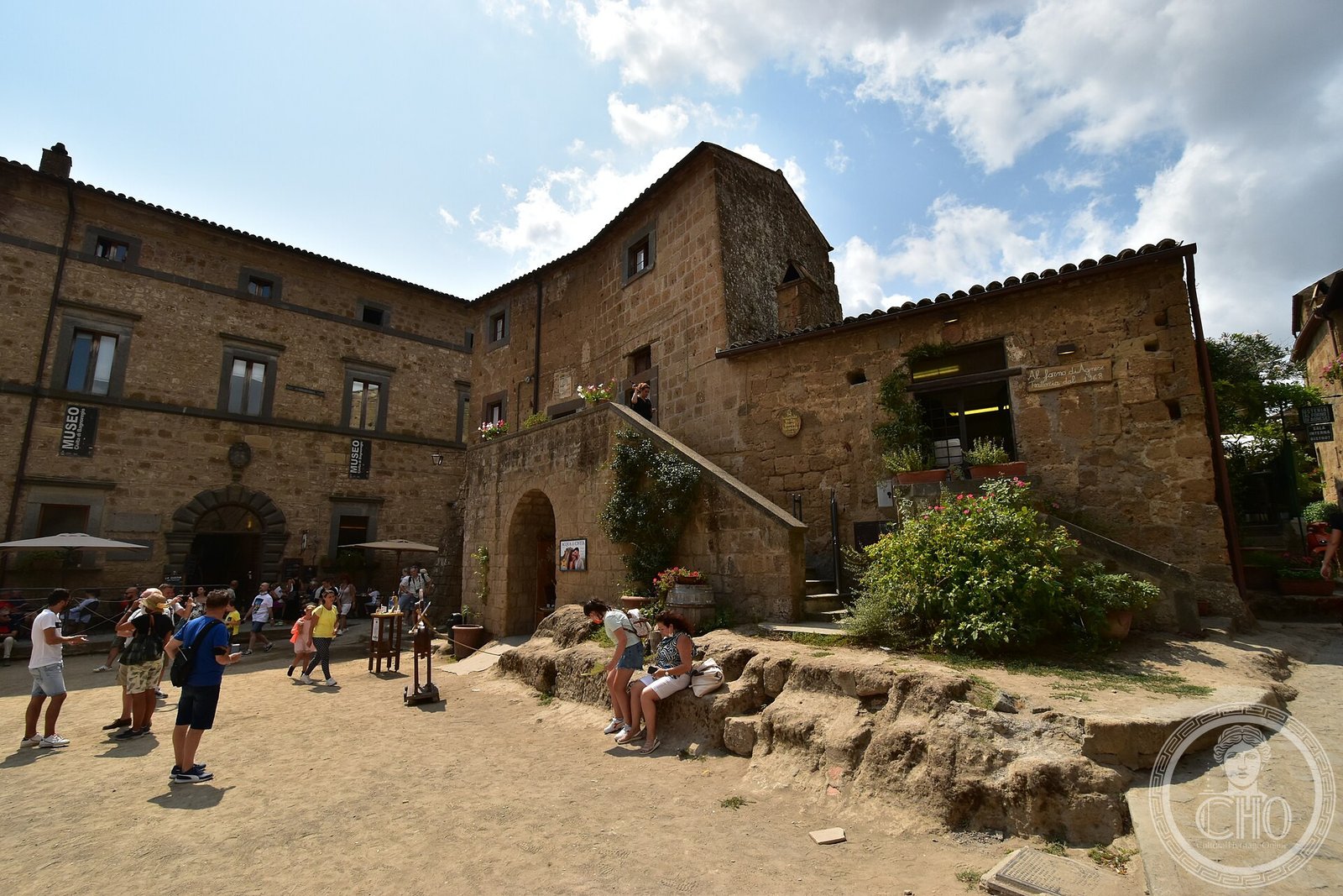
The Museo Geologico delle Frane (Geological Museum of Landslides), housed in the historic Palazzo Alemanni, is a specialist science and heritage museum located in or near Civita di Bagnoregio — one of the most dramatic examples of active geological erosion in Italy. The museum documents the processes of tufa erosion, landslide dynamics, and the centuries-long transformation of the volcanic plateau on which Civita stands, a phenomenon that has earned the village the poignant local epithet la città che muore — the dying city. The Palazzo Alemanni itself is a historic building that lends the collection an architectural and civic context rooted in the territory’s own human and geological history.
At a glance
- Type
- Geological and natural history museum; historic palazzo
- Period
- Palazzo of historic origin; museum established in the contemporary era
- Style
- Civic palazzo architecture typical of Lazio hill towns; volcanic tufa construction
- Location
- Bagnoregio area, Province of Viterbo, Lazio · 42.6276° N, 12.1109° E
Overview
Civita di Bagnoregio is an outlying village of the Comune of Bagnoregio in the Province of Viterbo, Lazio, positioned approximately 120 kilometres north of Rome. The village occupies the summit of a tufa mesa rising above two deep ravines carved by the Tiber tributaries — an erosive process that has isolated the historic settlement on an ever-narrowing promontory connected to the modern town only by a narrow pedestrian bridge. The Museo Geologico delle Frane translates this dramatic landscape into scientific narrative, explaining the geology of the volcanic Vulsini district and the mechanisms of the landslides that have been consuming the mesa’s flanks for centuries.
The Palazzo Alemanni, which hosts the museum, is one of the historic buildings that constitute the small but architecturally significant built fabric of Civita di Bagnoregio itself or the adjacent Bagnoregio town. Such palazzi in hill towns of northern Lazio typically date from the Renaissance or early modern period and reflect the civic ambitions of local noble or merchant families.
The museum’s focus on frane (landslides) positions it as a rare example of a heritage institution that directly addresses the geological risk threatening its own host settlement — an unusual and intellectually honest approach to place-based heritage interpretation.
History
The geological story of the Civita di Bagnoregio area spans hundreds of thousands of years, beginning with the volcanic activity of the Vulsini caldera (Lake Bolsena) that deposited the thick tufa and tuff layers now exposed in the surrounding ravines. The Etruscans settled the plateau by the fifth century BC, and the town of Bagnoregio grew from a medieval comune controlling the surrounding agricultural territory.
Landslide activity has been documented at Civita since at least the Renaissance, when early modern writers noted the progressive collapse of the plateau’s flanks. A catastrophic landslide in 1695 destroyed much of the old town of Civita and displaced its population to the neighbouring settlement now called Bagnoregio, leaving the original site increasingly isolated. By the twentieth century only a handful of permanent residents remained in Civita itself.
The establishment of the Museo Geologico delle Frane reflects the growing recognition of Civita di Bagnoregio’s global heritage significance: the site was inscribed as a candidate for UNESCO World Heritage status, attracting international scientific and touristic attention to both its geological fragility and its cultural value.
What you see
The museum displays geological specimens, stratigraphic models, and interpretive materials explaining the tufa formations, erosion rates, and landslide typologies of the Bagnoregio area. Maps and diagrams chart the progressive loss of the mesa’s surface over recorded history, giving visitors a quantitative sense of the landscape transformation underway.
The Palazzo Alemanni provides an architectural setting of historic substance: stone-vaulted rooms or timber-ceilinged halls typical of a Lazio noble residence of the Renaissance or Baroque period, with the building’s own masonry offering a tangible example of the tufa construction that characterises the entire settlement.
Views from Civita di Bagnoregio itself — accessible by the pedestrian bridge from Bagnoregio — remain among the most photographed in central Italy: the isolated rock mesa, the surrounding ravines, and the unchanged medieval streetscape of the village combine to produce a landscape of extraordinary visual power.
Cultural significance
The Museo Geologico delle Frane occupies a unique interpretive position: it is at once a science museum, a heritage centre, and a monument to the fragility of human settlement in geologically active landscapes. Its location at — or in proximity to — Civita di Bagnoregio gives the collection an urgency that is rare in Italian museum practice, since the processes it documents are actively reshaping the landscape visible from its windows.
Civita di Bagnoregio is considered a paradigmatic case study in the Italian and international debate over the conservation of heritage in geological risk zones, cited in academic literature on landscape heritage, geoheritage, and the ethics of tourism at endangered sites.
Practical information
- Address
- Palazzo Alemanni, Bagnoregio, Province of Viterbo, Lazio, Italy
- Hours
- Check the Comune di Bagnoregio or local tourist office for current museum opening hours
- Admission
- Check official sources; note that Civita di Bagnoregio charges an entry fee for the pedestrian bridge since 2017
Getting there
Bagnoregio is located approximately 120 km north of Rome and 30 km east of Orvieto. By car, take the A1 motorway to Orvieto, then the SR71 towards Bolsena and follow signs for Bagnoregio. Bus services connect Viterbo (served by regional trains from Rome Ostiense) to Bagnoregio; Orvieto station (on the high-speed Roma–Firenze line) provides the most convenient rail access. From Bagnoregio town, Civita di Bagnoregio is reached on foot via the bridge (approximately 10 minutes). No vehicles are permitted on the bridge or in Civita.
Sources & resources
- Comune di Bagnoregio — official tourist and cultural information
- Wikipedia: Civita di Bagnoregio
- Cultural Heritage Online — Italian and world heritage guides
See the place
Find it on the map
See this place and what’s around it →📷 Become a Cultural Heritage Online photographer
Share your photos of places: they stay published under your name as the author. The more they're seen, the more you get noticed — and soon a contest will reward the most appreciated photos.
Log in or sign up free to add a photo