
The second-largest island in Okinawa Prefecture, Iriomote remains one of Japan’s most remote and undeveloped destinations, accessible only by ferry and ringed by pristine subtropical wilderness.
At a glance
Iriomote Island spans 289 square kilometers and supports a population of roughly 2,350 residents. No airstrip serves the island; ferries from nearby Ishigaki carry over 390,000 annual visitors across a 31-kilometer strait to two ports on opposite coasts. The island belongs administratively to Taketomi Town.
History
Iriomote is part of the Yaeyama Islands, which form the southwesternmost archipelago of the Japanese island chain. Limited infrastructure and its remote location have preserved the island’s character throughout modern development.
What you see
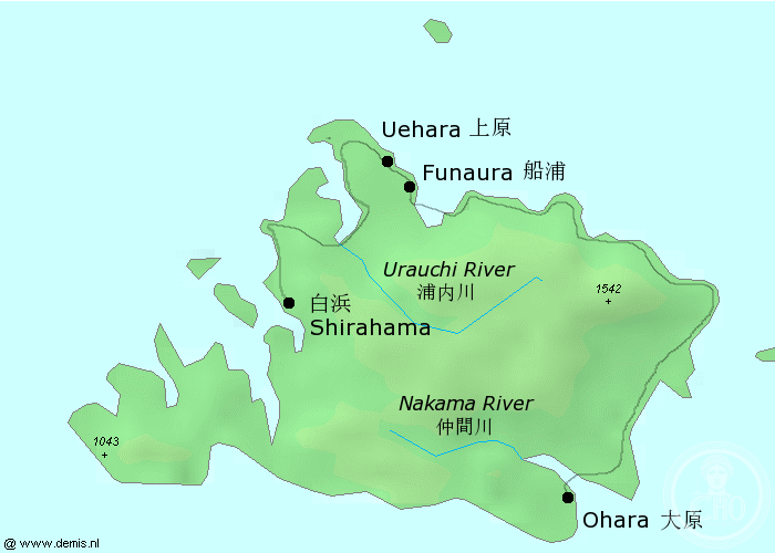
A single coastal road links scattered hamlets on the northern and eastern shores, forming the island’s primary transportation artery. Most of Iriomote remains undeveloped, with dense subtropical forest dominating the interior and steep terrain defining the landscape.
Cultural significance
Iriomote represents a rare example of Japan’s subtropical heritage, with distinct linguistic and cultural traditions preserved among its Yaeyama-speaking inhabitants. The island’s isolation has made it crucial for biodiversity conservation in the region.
Key facts
- Country: Japan
- Prefecture: Okinawa
- Area: 289.27 km² (111.69 sq mi)
- Population: 2,347 (2005)
- Coordinates: 24.34°N, 123.81°E
- Ferry distance from Ishigaki: 31.4 km (19.5 mi)
Practical information & getting there
You can reach Iriomote by ferry from Ishigaki Island. Two ports serve the island: Uehara Port on the northeast coast and Ōhara Port on the southeast coast. The journey takes approximately one hour. Once there, a single coastal road provides access to inhabited areas; exploring the interior requires hiking or local guides.
Sources & resources
Find it on the map
See this place and what’s around it →📷 Become a Cultural Heritage Online photographer
Share your photos of places: they stay published under your name as the author. The more they're seen, the more you get noticed — and soon a contest will reward the most appreciated photos.
Log in or sign up free to add a photo