
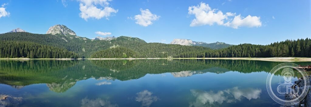
In the north of Montenegro, the Durmitor massif brings together sharp peaks, coniferous forest and a crown of glacial lakes that the people here call mountain eyes. At its foot opens the canyon of the river Tara, one of the deepest in Europe. A wild, luminous alpine landscape in the heart of the Balkans.
At a glance
Durmitor National Park, in the mountains of northern Montenegro, is a dramatic alpine landscape shaped by ice and water. The Durmitor massif rises in sharp limestone peaks above coniferous forest and rolling highland, dotted with eighteen glacial lakes known as “mountain eyes”, the largest and best loved being the Black Lake (Crno jezero). At its edge plunges the canyon of the Tara River, among the deepest gorges in Europe. This wild and luminous landscape was inscribed by UNESCO in 1980.
Key facts
- UNESCO: World Heritage since 1980 (Durmitor National Park)
- Glacial lakes: eighteen “mountain eyes”, led by the Black Lake
- Tara Canyon: among the deepest river canyons in Europe
- Sharp peaks: limestone summits above forest and highland
- Forests: ancient black pine and conifer woods
- Wildlife: bears, wolves, chamois and golden eagles
History
The Durmitor massif was carved by glaciers in the ice ages, which left behind its cirques, sharp ridges and the chain of high lakes. The Tara River, meanwhile, cut down through the limestone over millions of years to form its spectacular canyon, walled by cliffs over a thousand metres high in places.
The region has long been home to highland communities, with the small town of Žabljak as its centre, and is rich in folklore. Protected as a national park and inscribed by UNESCO in 1980, Durmitor is now a destination for hiking, rafting the Tara and winter sports, while keeping its wild, unspoilt character.
What you see
The most-visited spot is the Black Lake, ringed by forest and reflecting the peaks, with an easy trail around its shore; beyond, hiking routes climb to higher lakes and summits such as Bobotov Kuk. The Tara Canyon, crossed by the great Đurđevića Tara bridge, is famous for white-water rafting through its gorge.
The serenity of the mirror-still lakes beneath the peaks is the image many keep of Durmitor.
Practical information
- Park: trails from Žabljak; rafting on the Tara; skiing in winter
- Best time: summer for hiking; winter for snow sports
- Time needed: one to three days
- Setting: in the mountains of northern Montenegro
Getting there
Durmitor National Park is in northern Montenegro, around the town of Žabljak, reached by mountain road from Podgorica and the coast. GPS: 43.13° N, 19.05° E.
Nearby
- Žabljak — the highland town and park base
- Tara Canyon — the great gorge and rafting river
- Đurđevića Tara bridge — the landmark bridge over the canyon
Sources
- UNESCO World Heritage Centre — “Durmitor National Park” (ref. 100)
- National Parks of Montenegro — official body
- Encyclopaedia Britannica — Durmitor
Find it on the map
See this place and what’s around it →📷 Become a Cultural Heritage Online photographer
Share your photos of places: they stay published under your name as the author. The more they're seen, the more you get noticed — and soon a contest will reward the most appreciated photos.
Log in or sign up free to add a photo