

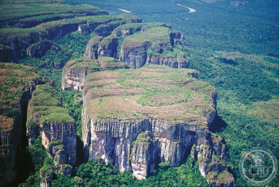
The world’s largest tropical rainforest national park, Chiribiquete spans nearly 43,000 square kilometres of pristine Amazonian wilderness in southeastern Colombia.
At a glance
Chiribiquete protects one of Earth’s most biodiverse and least-disturbed ecosystems. The park combines the distinctive Serranía de Chiribiquete mountains with surrounding lowlands of rainforest, savanna and river systems. Its vast territory ranks as Colombia’s largest national park and the world’s largest protected tropical rainforest.
History
The park was established on 21 September 1989, recognizing the ecological importance of this remote region. Two major expansions have significantly increased its protected area: the first in August 2013, and a second in July 2018, extending protection across an even greater landscape.
What you see
The Serranía de Chiribiquete mountains rise dramatically from the surrounding lowlands, their distinctive tabletop peaks creating a striking topography. Tropical moist forests blanket much of the terrain, interspersed with savannas and networks of rivers that sustain the ecosystem. The park’s geography remains largely unexplored.
Cultural significance
Chiribiquete represents one of the most important intact rainforest ecosystems on the continent. The park protects countless species found nowhere else and plays a crucial role in global climate regulation through carbon storage. It is designated a UNESCO World Heritage Site, acknowledging its irreplaceable natural value.
Key facts
- Area: 43,000 square kilometres (17,000 square miles)
- Location: Caquetá and Guaviare departments, Colombia
- Established: 21 September 1989
- Coordinates: 0.53°N, 72.80°W
- UNESCO World Heritage Site
Practical information & getting there
Access to Chiribiquete is extremely restricted to protect the fragile ecosystem and indigenous communities within its boundaries. The park remains largely inaccessible to the general public. For information about scientific research or special permits, contact Colombia’s National Natural Parks Unit (Parques Nacionales Naturales de Colombia).
Sources & resources
Find it on the map
See this place and what’s around it →📷 Become a Cultural Heritage Online photographer
Share your photos of places: they stay published under your name as the author. The more they're seen, the more you get noticed — and soon a contest will reward the most appreciated photos.
Log in or sign up free to add a photo