
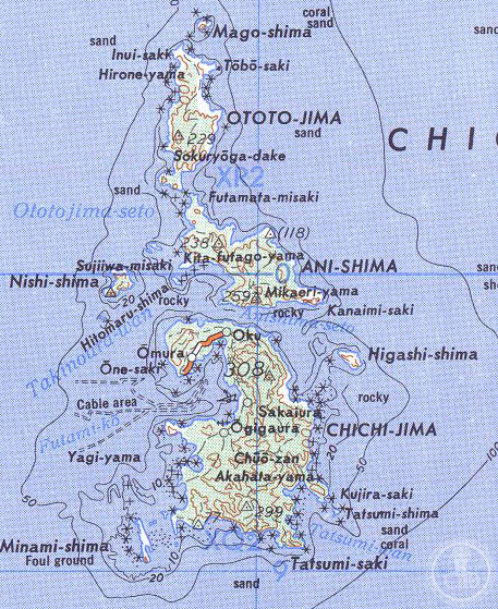
The largest of the Bonin Islands, Chichijima remains a remote outpost 240 kilometers north of Iwo Jima, accessible only by ferry and home to a distinctive community shaped by centuries of isolation and international settlement.
At a glance
Chichijima covers 23.5 square kilometers and supports approximately 2,120 residents. The island serves as the administrative seat of Ogasawara Village, part of Tokyo’s distant Nanpō Islands chain. A ferry service connects it to the mainland only a few times monthly, requiring a full day of travel each way.
History
Though Micronesian tools and carvings suggest early Pacific contact elsewhere in the Bonins, Chichijima itself was long uninhabited when European powers arrived. Spanish, Dutch, and Japanese mariners passed it by for centuries until a British captain claimed the island in 1828.
Two years later, an international group from the Hawaiian Kingdom settled here, establishing the original Bonin Islander community. Japan subsequently colonized the island, founding two administrative villages—Ōmura and Ōgimura-Fukurosawa—formally incorporated in 1940. World War II brought forced evacuation of civilians to Honshu in 1944.
American occupation followed Japan’s surrender, lasting two decades. The United States restricted resettlement to ethnic Bonin Islanders while demolishing Japanese structures. Japan resumed control in 1968, after which ethnic Japanese populations increased rapidly.
What you see
Futami Port (Port Lloyd), the chief harbor of the Bonin Islands, dominates Chichijima’s northern coast and serves as the primary point of entry for all visitors. A major village clusters around this working port, reflecting the island’s maritime character and practical orientation toward the sea.
Cultural significance
Chichijima embodies the complex cultural crosscurrents of the Pacific. Its settlement by islanders from Hawaii created a distinctive Bonin Islander identity that persists today despite Japanese administrative control and demographic shifts. The island’s isolation and limited accessibility have preserved this unique heritage.
Key facts
- Country: Japan
- Location: Ogasawara Village, Tokyo Metropolitan Government
- Coordinates: 27.07°N, 142.21°E
- Area: 23.5 square kilometers
- Population: approximately 2,120 (2021)
- Access: Ferry service, a few times monthly
Practical information & getting there
You arrive at Futami Port on Chichijima’s northern shore via ferry from the Tokyo metropolitan area. The journey takes approximately one day each way, and services run only several times per month, requiring advance planning. The port remains the sole point of entry and functions as the commercial hub of the Bonin Islands.
Sources & resources
Find it on the map
See this place and what’s around it →📷 Become a Cultural Heritage Online photographer
Share your photos of places: they stay published under your name as the author. The more they're seen, the more you get noticed — and soon a contest will reward the most appreciated photos.
Log in or sign up free to add a photoIs this page about you?
This page is read by travellers and heritage enthusiasts who find it on Google. Tell us how you are connected to this place and we will take it from there.