

On a spur above the Beirut river, a Roman sanctuary to a Semitic god of dancing, a sixth-century church built inside a bath hall, and a monastery of the Antonine Maronite Order whose front door sits on the temple’s own foundations.
At a glance
Deir el-Qalaa — the name means the convent of the citadel — stands at the southern edge of Beit Mery, on a rocky spur some seventeen kilometres inland from Beirut, looking down on the Nahr Beirut, the river the Romans called Magoras. The hilltop carries three phases at once. A Roman sanctuary of the imperial period, with a great temple of Jupiter Balmarcod and at least one smaller one, is the lowest; a Byzantine settlement with baths, olive presses and a sixth-century basilica sits in and over it; and since 1748 the Antonine Maronite Order has held the site, building its monastery and its church of Saint John the Baptist into the temple’s own foundations. The archaeological area covers about a hectare and is open ground.
Key facts
- Where: Deir el-Qalaa, Beit Mery, Metn district, Mount Lebanon governorate
- The god: Balmarcod, whose name is read from the Semitic root for dancing, hence “lord of the dance”; in the Latin inscriptions he appears as Jupiter Balmarcod, alongside Juno Regina
- The great temple: prostyle, facing north-west towards Beirut and the sea, with no podium and two internal staircases; usually dated to the second century AD. Four column shafts and a fifth pedestal were still standing in 1852; one column is built into the monastery wall and another stands in its crypt.
- The second temple: a prostyle tetrastyle building 11.3 by 8.6 metres at the east end of the precinct, its scattered material found in the 1960s and partly reassembled
- Also on the site: public and private baths, a nymphaeum, a monumental gateway on the processional way between the two temples, olive presses, a colonnaded street and a quarter of houses and workshops
- The basilica: three-aisled, sixth century, built inside a hall of the Roman baths
- Inscriptions: more than a hundred Greek and Latin texts, many reused in the convent walls; dedications to the gods of Berytus and of Heliopolis and to Trajan, Hadrian and Septimius Severus
- The monastery: the Antonine Maronite Order took the site around 1748; the church of Saint John the Baptist carries the date 1768 over its west door
- Altitude: about 732 metres for the sanctuary; Beit Mery itself stands at roughly 750–800 metres
- Coordinates: 33.855314, 35.597203 · open in Google Maps
History
Travellers knew the place from the middle of the eighteenth century. In 1846 a German visitor compared its columns to those of the temple of the Sun at Baalbek; Ernest Renan, in the Mission de Phénicie of 1860–61, called it the last great temple of Lebanon that one meets going south. Edward Robinson and Eli Smith climbed up on 13 March 1852 and found the temple front facing north-west over the plain and the sea, four column shafts and one pedestal still in place, and no capitals at all. They also counted eight or ten Greek and Latin inscriptions built at random into the walls and other parts of the convent, one of them a short Latin text in the dative: IOVI BALMARCODI.
The sanctuary was Roman in its architecture and Semitic in its god. Balmarcod’s name is read from the root that gives the verb to dance, which is why he is called the lord of the dance; the inscriptions equate him with Jupiter and pair him with Juno, styled both goddess and queen. Others in the same precinct honour the Genius and the Fortuna of the colony of Berytus and the gods of Heliopolis, and name Trajan, Hadrian and Septimius Severus. A processional path ran between the two temples, under a monumental gateway that probably marked the boundary of their sacred grounds. Vici’s summary of Julien Aliquot’s study adds that the great temple had no podium and two internal staircases to its upper parts.
What happened next is legible on the ground. When the temples fell out of use, buildings around them were turned to farming — the millstones are still there — and in the sixth century a three-aisled basilica was built inside a hall of the Roman baths. The mosaic floor of that church is dated to the sixth century on its style, and was probably laid before the earthquake of 551 that destroyed Berytus.
The Antonine Maronite Order acquired the hill around 1748 and built on it. The church of Saint John the Baptist carries an inscription over its west door recording the dedication, with the date 1768; one Lebanese account reports that site studies date the surviving fabric to the nineteenth century, and that the 1768 church stood in the place of a still earlier one, raised on the front of the temple, which collapsed under its own size. The monastery was burned twice during the Druze–Maronite conflicts between 1840 and 1860, occupied by the Ottoman army in the First World War, and badly damaged in the Lebanese civil war, when monks were killed and the rest fled; the building was afterwards used as a barracks by the Syrian army until 2005. Restoration followed, some of the new mosaic work done with the help of craftsmen from Ravenna, and the monastery now holds concerts, exhibitions and public events alongside its liturgy.
The archaeology has a gap at its centre. The excavations that actually uncovered the site were run in the 1960s and 1970s by Haroutine Kalayan, an engineer of Lebanon’s Directorate General of Antiquities, and were never published. The site’s definitive study appeared only in 2023, as a special volume of the Directorate’s own bulletin, with the temple, the convent church and the baths each treated separately. We have not been able to open that volume and report it here at second hand.
What you see
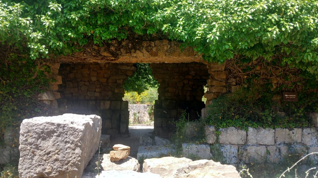
The archaeological area is not fenced and not ticketed: open ground, dry grass in summer, a scatter of cut blocks and drums, and paths worn between them. Walls of coursed limestone stand a course or two high, with occasional taller stubs of pier; a broken column shaft in dark stone rises among them; here and there a squared block lies where it fell, and a plain cut lintel spans two rubble piers. In one part of the site a hall has been rebuilt by the excavators, and creeper has grown over the top of it, which has given a reconstruction the look of a ruin. Small brown enamel signs mark what is what — one of them reads ROMAN-BYZANTINE BATH.
Inside the baths the floors are broken through in places, and the terracotta pipes that carried the hot air are visible under them; one hall keeps its hypocaust and patches of marble and stucco facing. The rooms are graded cold, tepid and hot in the usual way.
A caution about the mosaic. Excavators found the Byzantine church sitting inside one of the bath halls and decided that both deserved to be seen, so they lifted the church’s floor and some of its architecture, rebuilt the bath hall underneath, and set the church’s columns, plinths and mosaic pavement down beside it. The mosaic is therefore on the site but not where it was laid. Its ornament is geometric — diamonds and circles alternating, with swastika meanders and Solomon’s knots — with plants and birds among the geometry.
At the north-west end, the monastery. Its door stands on the line of the temple front; a column is built into its wall and another stands in the crypt, and the temple’s walls run further east than the convent does and come out again on the other side. In the garden, inscribed pedestals: one for a statue of the Genius of the colony of Beirut, one offered by a woman named Antistia Victorina Fabaria, one dedicated to Jupiter Optimus Maximus Balmarcod and to Juno.
Practical information
- The archaeological area is open ground and can be walked freely; we have found no source giving an admission charge or official opening hours for it.
- The monastery is a working religious house of the Antonine Maronite Order and should be treated as one.
- The site is unshaded and uneven; the stone is slippery after rain.
- The order’s technical institute operates in the monastery, and the buildings are used for concerts, exhibitions and public gatherings.
Getting there
Beit Mery is about seventeen kilometres east of Beirut, up the road towards Broummana, roughly half an hour from the city without traffic. Deir el-Qalaa lies at the southern edge of the town: from the lower end of the main street, past St George’s church, the road continues uphill and round the bend past the municipality building to the site.
Nearby
- The eastern belvedere of Deir el-Qalaa, a few hundred metres away, with the view down to Beirut and the sea.
- The old centre of Beit Mery and its pine woods, on the ridge above.
- Broummana, the next hill town along the ridge.
- Beirut itself and the National Museum, half an hour down the mountain.
Sources
- Jean-Paul Rey-Coquais, “Deir el-Qalaa”, Topoi 9/2 (1999), 607–628: the position above the Nahr Beirut, the ancient name Magoras, the site known since the mid-eighteenth century, Renan’s judgement in the Mission de Phénicie, W. Kraft’s comparison with Baalbek in 1846, the reuse of the inscriptions in the convent walls, and the central fact that the excavations by Haroutine Kalayan of the Directorate General of Antiquities have remained unpublished.
- Vici.org, “Roman Temple of Baal Markadi-Jupiter, Deir al Qal’a”, drawing on Julien Aliquot, La Vie religieuse au Liban sous l’Empire romain (Beirut, Ifpo, 2009), 268–271, and George Taylor, The Roman Temples of Lebanon (1967): the second-century date and the destruction in the earthquake of 551, the prostyle plan opening north-west, the columns in the monastery wall and crypt, the absence of a podium and the two internal staircases, the second temple at 11.3 by 8.6 metres, the sixth-century three-aisled basilica, the baths partly overlaid by it, the nymphaeum and the oil presses.
- Roberto Piperno, “Deir el Qalaa and Beit Mery”, romeartlover.it: the 1852 account of Robinson and Smith quoted at length, the inscriptions IOVI BALMARCODI and I O M B et Iunoni and the pedestals in the garden, the convent church built on and within the old foundations, the 1960s reassembly of the second temple, the processional path and the gateway, Ronzevalle’s report of 1900, the fires of 1840–60 and the Ottoman occupation, and the decision to lift the Byzantine church’s floor and architecture in order to rebuild and show the bath hall beneath it. (This page dates the Lebanese civil war as 1980–1995; it ran from 1975 to 1990.)
- SyriacPress, 20 September 2026: the Antonine Order’s acquisition around 1748, the church of the 1760s and the dedication inscription over the west door, the great temple at roughly 17 by 36 metres facing Beirut, the monastery’s fifteen to seventeen kilometres from the city, the restoration with mosaicists from Ravenna, the technical institute in the monastery, and the concerts, exhibitions and festivals held there.
- Discover Lebanon, “Deir el Kalaa, Beit Mery”: the grant of the property in 1748 by Emir Youssef Mrad Abi Allamah, the first stone laid in 1747, the church completed in 1762, the nineteenth-century halls and dome, the damage in the civil war and the restoration from 1996, and the present use for concerts, exhibitions and conferences.
- UNESCO World Heritage Centre — Lebanon: consulted to confirm that Deir el-Qalaa is on neither the inscribed list nor Lebanon’s tentative list.
- OpenStreetMap / Nominatim — position, returned as دير مار يوحنا – دير القلعة, Place Mar Sassine, Beit Mery, Metn, Mount Lebanon.
- What we could not establish: any decree or published register entry classifying the site under Lebanon’s antiquities law. Lebanon’s Directorate General of Antiquities has no public website and the Ministry of Culture publishes no register of sites; what can be said is that the Directorate excavated the site itself, and published its definitive study — BAAL Hors-Série 19 (2023), with studies of the temple, the convent church and the baths — in its own bulletin. We report that volume at second hand, not having been able to open it. Dates for the great temple range from the first to the second century across the sources; the dimensions given for it come from weak sources and should be treated as approximate. The nineteenth-century dating of the present convent church rests on a single Lebanese newspaper account.
Find it on the map
See this place and what’s around it →📷 Become a Cultural Heritage Online photographer
Share your photos of places: they stay published under your name as the author. The more they're seen, the more you get noticed — and soon a contest will reward the most appreciated photos.
Log in or sign up free to add a photoIs this page about you?
This page is read by travellers and heritage enthusiasts who find it on Google. Tell us how you are connected to this place and we will take it from there.