
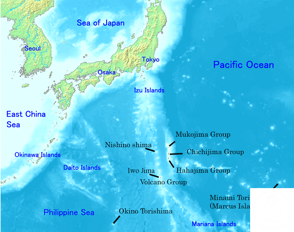
A remote Japanese archipelago 1,000 kilometers southeast of Tokyo, the Bonin Islands are a living laboratory of isolated evolution and a unique cultural crossroads shaped by centuries of maritime history.
At a glance
The Bonin Islands (Ogasawara in Japanese) comprise over 30 subtropical and tropical islands with a combined area of 84 square kilometers. Only Chichijima and Hahajima are permanently inhabited, with a total population of 2,560 as of 2021. The archipelago lies approximately 1,000 kilometers south-southeast of Tokyo and 1,600 kilometers northwest of Guam, making it one of Japan’s most isolated inhabited territories.
History
Archaeological evidence suggests Micronesian peoples visited the islands in prehistoric times, though they were entirely uninhabited when European explorers arrived in the early modern period. The Spanish, Dutch, and isolationist Japan largely ignored the archipelago until British captain Beechey claimed it in 1827. American, European, and Hawaiian colonists established settlements beginning in 1830, creating a distinctive multicultural community. Meiji Japan reclaimed and colonized the islands in 1875, but this period ended catastrophically during World War II, when most inhabitants were forcibly relocated to Honshu. Following Japan’s defeat, the US Navy occupied the islands, demolishing existing homes and restricting resettlement. Full Japanese control returned in 1968.
What you see
The islands themselves tell their geological story through volcanic formations and distinctive subtropical ecosystems. The settlement infrastructure reflects Japan’s 1875 colonization and post-war reconstruction, though earlier colonial-era structures were largely removed during American occupation.
Cultural significance
The Bonin Islands are justly celebrated as the “Galápagos of the Orient” for their remarkable biodiversity and unique evolutionary processes shaped by extreme isolation. Designated a Natural World Heritage Site in 2011, the archipelago represents irreplaceable natural heritage. Culturally, the islands embody an unusual fusion of Japanese, Hawaiian, European, and American influences—a legacy evident in the local Bonin English, a Creole language that persists as a living marker of the community’s distinctive past.
Key facts
- Country: Japan
- Location: Approximately 26.99°N, 142.22°E
- Area: 84 square kilometers (32 square miles)
- Permanently inhabited islands: 2 (Chichijima and Hahajima)
- Population: 2,560 (as of 2021)
- UNESCO Natural World Heritage Site: 2011
Practical information & getting there
Access to the Bonin Islands is primarily by sea from Tokyo, with ferry service available. Tourism has grown alongside improved transportation, though development remains limited and locally contentious—particularly regarding plans for an airport. The seat of government is Chichijima. Visitors should plan ahead for accommodation and supplies, as the islands’ isolation means limited commercial infrastructure.
Sources & resources
Find it on the map
See this place and what’s around it →📷 Become a Cultural Heritage Online photographer
Share your photos of places: they stay published under your name as the author. The more they're seen, the more you get noticed — and soon a contest will reward the most appreciated photos.
Log in or sign up free to add a photo