
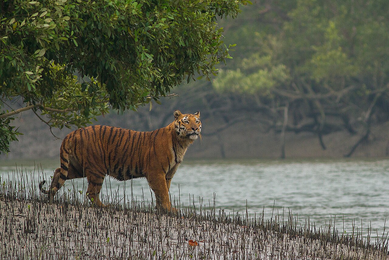
Sundarbans National Park (সুন্দরবন জাতীয় উদ্যান), inscribed by UNESCO in 1987, is the Indian portion of the Sundarbans — the world’s largest mangrove forest (approximately 10,000 km² total, of which the Indian Sundarbans encompasses approximately 4,262 km² of mangrove, tidal channels, and islands at the mouth of the Ganges-Brahmaputra-Meghna delta on the Bay of Bengal in West Bengal) — a unique ecosystem combining the largest river delta sediment system on earth with a globally significant mangrove forest that supports the world’s largest single population of the Bengal tiger (Panthera tigris tigris), a population with specific adaptations to the tidal mangrove environment (regular saltwater immersion, island-to-island swimming across tidal channels, dietary inclusion of fish and crustaceans alongside the standard deer prey of mainland tiger populations) that make the Sundarbans tigers ecologically distinct from all other Bengal tiger populations. The Sundarbans National Park was inscribed separately from the Sundarbans in Bangladesh (Sundarbans Wildlife Sanctuary, UNESCO 1997) — the international boundary between India and Bangladesh runs through the delta mangrove, dividing the single ecological unit of the Sundarbans between two national parks, though the tigers swim freely across the political boundary. The Indian Sundarbans National Park (the inner “core zone” of approximately 1,331 km²; the larger “Sundarbans Tiger Reserve” encompasses approximately 2,585 km²) is accessible from Kolkata (approximately 100 km by road to Gosaba or Canning, then by boat into the delta network) and protects a tiger population estimated at approximately 96–100 individuals (2019–2020 Indian government census using camera trap data across the full Indian Sundarbans Tiger Reserve area).
The Sundarbans mangrove ecosystem and the West Bengal–Bangladesh delta landscape Sundarbans core zone · Sajnekhali Wildlife Sanctuary · Gosaba · Kolkata — 0 to 120 km
The Sundarbans delta landscape — 54 islands in the Indian portion, none more than a few metres above sea level, separated by a complex network of tidal channels (khals) that flood and drain with the twice-daily Bay of Bengal tides — is navigated exclusively by boat, with no permanent road access within the national park boundary. Visitor access is via the government ferry service from Godkhali jetty (4 km from Gosaba, 100 km south of Kolkata) or from the Canning riverboat terminus, with permits from the Forest Department of West Bengal required for all entries into the park and buffer zone. The Sajnekhali Wildlife Sanctuary (at the entrance to the core zone, with the Forest Department’s watch tower, visitor centre, and crocodile rehabilitation pool) is the most accessible wildlife-viewing point. Wildlife encounters in the Sundarbans are exceptional in their unpredictability — the dense, impenetrable mangrove forest (the Sundari tree, Heritiera fomes, the dominant mangrove species after which the Sundarbans may be named, forms a closed canopy 15–20 metres above the tidal mud at its densest) makes visual sighting of tigers at distance impossible, unlike in the open grassland of Kaziranga or the dry deciduous forest of Bandhavgarh. Tiger sightings in the Sundarbans are rare and often brief — the most typical encounter is a tiger swimming across a channel ahead of a boat, or walking on the mudflat beside the channel edge. The mangrove ecosystem itself (the pneumatophore root systems of the sundari trees projecting from the tidal mud, the regular rise and fall of the channels with visible high-water marks on the vegetation, the estuarine crocodile (Crocodylus porosus) population that makes the Sundarbans the primary habitat of this species in eastern India, the Irrawaddy dolphin (Orcaella brevirostris) and Ganges River dolphin (Platanista gangetica) in the deeper channels) provides wildlife interest independent of tiger sightings.
The Sundarbans is one of the most climate-threatened UNESCO World Heritage sites on earth — systematic sea level rise (averaging approximately 3–5 mm per year in the Sundarbans delta, above the global average of approximately 3.3 mm per year, due to the combination of global sea level rise and tectonic subsidence of the Bengal delta) has already caused the submergence of several smaller islands in the Indian Sundarbans (Lohachara Island disappeared beneath the Bay of Bengal between 1975 and 1995 CE, displacing approximately 10,000 inhabitants; Suparibhanga Island fully submerged in the 1980s). The climate-related threats compound: tropical cyclones (the Bay of Bengal is one of the most cyclone-prone basins in the world; the 1970 Bhola Cyclone killed approximately 500,000 people in the Ganges-Brahmaputra delta; the Sundarbans provided significant storm surge buffering for Kolkata during Cyclone Aila 2009 and Cyclone Amphan 2020) become more intense with warming ocean temperatures; the mangrove forest itself migrates landward as sea levels rise, but the pace of sea level rise is now faster than the mangrove’s capacity for northward migration in a delta landscape where the land immediately north of the mangrove is densely settled agricultural territory. UNESCO’s 2021 Outlook Report classified the Indian Sundarbans as “Significant concern” on its conservation outlook scale — the first step below “Critical” on the UNESCO monitoring hierarchy.
Practical information
The Sundarbans is accessed from Kolkata (approximately 100 km to the delta gateway towns of Canning or Basanti/Godkhali). By train from Sealdah Station (Kolkata’s eastern terminus): to Canning (approximately 1 hour, frequent local trains). By road: to Sonakhali jetty (approximately 2.5 hours from Kolkata’s Esplanade bus terminus). From the jetty towns, all access to the park is by boat (government launches and private boats are both available; country boats — small motorised vessels — can navigate the smaller channels but offer no protection in rough weather). Forest Department permits are required for all zones; core zone permits are issued at the Sajnekhali permit office and must be obtained a day in advance during peak season. Two-day package tours from Kolkata (overnight on a forest department launch) are the most practical visitor format — they include the permits, the Forest Department naturalist guide, and meals. Individual visitor arrangements are possible but require advance planning. Best visiting months: September–February (post-monsoon when the mangrove canopy has maximum bird life, the channels are navigable without cyclone risk, and temperatures are 18–28°C; the tiger spotting probability is highest November–February when reduced cover allows occasional clear sightings). Accommodation ranges from basic forest department bungalows (in Sajnekhali and Bhagabatpur) to the Sundarbans Jungle Camp in Gosaba (a popular eco-tourism operator). Permits, tour operator contacts, and boat hire information: through the West Bengal Forest Department Sundarban Division (Canning) or authorised eco-tourism operators.
Frequently Asked Questions
Why are the Sundarbans tigers considered different from other Bengal tigers?
The Bengal tiger population of the Sundarbans (Panthera tigris tigris — all tigers from the South Asian subcontinent are the Bengal tiger subspecies; the subspecific designation applies to the entire Indian, Bangladeshi, Nepalese, and Bhutanese population, not to a specific population within India) is documented to display several behavioural and ecological characteristics that distinguish it from the mainland tiger populations of Rajasthan (Ranthambore), Madhya Pradesh (Kanha, Bandhavgarh), Karnataka (Nagarhole, Bandipur), and Assam (Kaziranga, Manas). These characteristics include: regular saltwater immersion (the tidal channels of the Sundarbans rise and fall by approximately 5–7 metres twice daily; tigers in the Sundarbans are photographed and observed swimming these channels routinely, and the daily immersion in salt water — which would cause health problems in animals not physiologically adapted — has been documented by camera trap studies to be normal behaviour for Sundarbans tigers from early age; the specific physiological mechanism by which Sundarbans tigers tolerate chronic saltwater exposure without the kidney damage that would be expected in non-adapted individuals is not fully understood and represents an active area of veterinary research); a significant dietary proportion of fish and crabs (Sundarbans tigers have been observed catching fish in tidal pools and consuming horseshoe crabs and mud crabs from the mangrove mudflats — a dietary flexibility not documented in mainland populations where ungulate prey is the overwhelmingly dominant food source); and island-territory ranging patterns (where individual tiger home ranges in the Sundarbans, constrained by the tidal channel network, overlap extensively with human-inhabited islands around the park boundary — creating the human-tiger conflict situation responsible for the Sundarbans’ historical “man-eating” reputation). The “man-eating” label for Sundarbans tigers — widely applied in colonial literature and persisting in international media coverage — requires contextualisation: the documented attacks on humans in the Sundarbans are almost entirely attributable to specific individual tigers that have developed a pattern of targeting humans (typically honey collectors, fishermen, and woodcutters who enter the park illegally or whose traditional livelihood activities bring them into the forest), rather than a widespread characteristic of the population; the Forest Department statistics document approximately 20–30 tiger attack fatalities per year in the Indian Sundarbans in the 1980s–1990s (higher than in any other Indian tiger reserve), declining to approximately 3–5 per year in the 2010s following improved community buffer programs and law enforcement. The specific ecological reason why human-tiger conflict is elevated in the Sundarbans compared to mainland reserves is straightforwardly the geography: in Sundarbans, the tiger’s natural habitat is an island-network without clear physical separation from human agricultural and fishing settlements; the human communities of the Sundarbans periphery have lived in immediate adjacency to tigers for centuries, and the historical practice of entering the mangrove for resources (honey, fish, wood) is economically essential for communities with few alternative livelihoods.
How is the Sundarbans mangrove forest significant in protecting the West Bengal and Bangladesh coast from cyclones?
The Sundarbans mangrove forest functions as a natural coastal protection system of measurable value — a “green infrastructure” of approximately 10,000 km² of densely vegetated coastal forest that reduces cyclonic storm surge heights, wave energy, and flooding penetration inland, at a scale that is globally significant as the most extensive natural coastal storm buffer on earth. The specific mechanism of mangrove storm protection involves: wave attenuation (the pneumatophore root systems, aerial roots, and dense stem structure of the mangrove forest reduce wave height by approximately 50–70% per 1 km of mangrove width — measured empirically in the aftermath of the 2004 Indian Ocean tsunami, when coastal areas with intact mangrove cover sustained significantly less damage than adjacent deforested areas at similar distances from the coast, a difference documented in satellite imagery analysis by researchers at the US Geological Survey); wind speed reduction (the mangrove canopy reduces wind speed within the forest by approximately 20–30% compared to open water); and storm surge height reduction (the mangrove root system and forest floor accumulate sediment that raises the land surface, and the forest structure itself acts as a baffle against the wall of water that a major cyclone pushes inland). The quantified protection value was most clearly demonstrated during Cyclone Aila (May 2009, a very severe cyclonic storm that made landfall directly on the Sundarbans with wind speeds of approximately 110 km/h and storm surges of 3–5 m): the villages immediately behind the Sundarbans mangrove experienced flooding but survived; several communities on islands within the mangrove where the protective forest had been cleared for aquaculture (shrimp farming) were catastrophically damaged with complete house destruction and significant loss of life. The economic value of the Sundarbans mangrove as storm protection has been estimated in several academic studies (the most frequently cited is the Costanza et al. 2008 study estimating the value of all coastal protection services of world mangroves at approximately $1.6 million per km² per year — the Sundarbans’ approximately 10,000 km² would represent approximately $16 billion per year in storm protection services, a calculation that is widely used in policy advocacy for mangrove conservation funding). The accelerating sea level rise in the Bengal delta creates a specific feedback problem for this protection function: as sea levels rise, the mangrove’s position in the intertidal zone shifts, but the pace of the migration is limited by the rate at which the mangrove can establish on newly available intertidal terrain; if sea level rise outpaces mangrove migration, the buffer zone between the ocean and human settlements narrows. The projected scenario in which the Sundarbans mangrove is reduced by 25–30% by 2050 CE through sea level rise (the medium scenario in the IPCC’s Sixth Assessment Report regional impact projections for the Bengal delta) would reduce the coastal protection function proportionally — creating increased cyclone vulnerability for approximately 4 million people in the West Bengal Sundarbans periphery villages and for the low-lying coastal areas of Kolkata and the Hooghly River delta.
EXCERPT: Sundarbans National Park, UNESCO-inscribed in 1987, is India’s portion of the world’s largest mangrove forest (10,000 km² across India and Bangladesh) — home to approximately 96–100 Bengal tigers adapted to swimming saltwater channels, estuarine crocodiles, Irrawaddy dolphins, and one of the planet’s most climate-threatened UNESCO sites with islands already submerged.
META: UNESCO World Heritage Sites near Sundarbans National Park West Bengal India: Sundarbans Bangladesh 0 km east (same ecosystem, UNESCO 1997), Kaziranga National Park 600 km northeast (UNESCO 1985) — West Bengal Bay of Bengal UNESCO natural heritage, Bengal tiger mangrove habitat, Bengal delta climate change threatened heritage site.
Sources
- S1 — UNESCO World Heritage Centre — Sundarbans National Park (Ref. 452) — https://web.archive.org/web/20230601000000/https://whc.unesco.org/en/list/452/
- S2 — UNESCO World Heritage Centre — Statement of Outstanding Universal Value (Ref. 452) — https://whc.unesco.org/en/list/452/
Spotted an error? Write to [email protected] and we correct it the same day.