Oman maintains approximately 3,000 active aflaj — underground gravity-fed irrigation channels that have delivered mountain groundwater to desert settlements without pumps or motors for at least 1,500 years. Five of these systems received UNESCO World Heritage inscription in 2006 as representative of one of the world’s most sophisticated pre-industrial hydraulic engineering traditions. The inscribed aflaj are distributed across Nizwa, Izki, Al-Mudayrib, and Birkat Al-Mauz, each still in daily agricultural use.
Engineering Without Engines: How the Aflaj Move Water Across the Desert Interior Oman, Hajar Mountains region
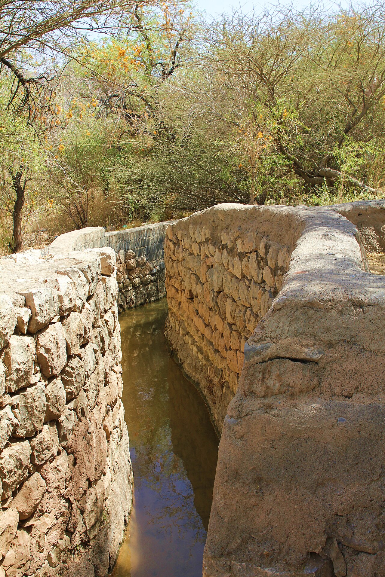
A falaj (the singular form; aflaj is the plural) is an underground channel that begins at a qanat shaft sunk into a mountain aquifer, collects groundwater by gravity, and conducts it through a gently sloping tunnel to agricultural land several kilometres away. The tunnel descends at a precisely calculated gradient — too steep and the water erodes the channel floor; too shallow and the water stagnates. The shaft interval allows the builders to clear sediment, measure flow rates, and ventilate the tunnel during construction and maintenance. The same technology is called qanat in Iran and Central Asia, karez in Afghanistan and Pakistan, and foggara in North Africa. The Omani term falaj derives from the Arabic root meaning division or distribution, which describes the system’s function as accurately as its construction.
The five UNESCO-inscribed aflaj are: Falaj Daris near Nizwa, Falaj Al-Khatmeen and Falaj Al-Mayassar in Izki, Falaj Al-Jeela in Al-Mudayrib, and Falaj Al Malki at Birkat Al-Mauz. Each was chosen because it exemplifies a particular aspect of the broader falaj tradition: Falaj Daris for its scale and continuous operation, the Izki systems for their antiquity and community governance records, Falaj Al-Jeela for its integration into a still-functioning agricultural village, and Falaj Al Malki for its relationship to the plantation landscape of date palms at Birkat Al-Mauz.
Falaj Daris, the most visited of the inscribed systems, runs approximately 3 kilometres from the foothills of the Western Hajar Mountains to the Nizwa oasis. Its flow is measured using a sunstick — a calibrated wooden rod that casts a shadow of known length at known times of day, translating shadow-time into water volume. The channel irrigates date palms, citrus trees, and vegetable plots in the oasis around Nizwa Fort. The flow rate is consistent year-round because the system draws from the deep aquifer rather than from seasonal runoff.
The archaeological evidence for Omani aflaj construction extends into the pre-Islamic period, placing some systems within the first millennium BCE in the broader regional tradition. Documentary evidence confirms operation of specific Omani systems by at least 500 CE. Local tradition attributes the introduction of the technology to Sulayman ibn Daud — the prophet Solomon — but this origin story reflects the cultural prestige of the technology rather than documented history. The oldest physical evidence for qanat construction anywhere in the world comes from Iran and dates to approximately the 8th century BCE; the Omani tradition is a regional adaptation of that wider system.
What makes the Omani aflaj distinctive within the global qanat tradition is not their scale — Iranian qanats can be 50 kilometres long — but their density and their survival as living agricultural infrastructure. The landscape of interior Oman is organised almost entirely around these channels. Every traditional village in the region was built adjacent to a falaj because there was no other source of perennial water. When a falaj failed through seismic damage, aquifer depletion, or neglect, the village it served was typically abandoned within a generation.
Water Auctions at Dawn: The Social System That Keeps the Channels Running Nizwa and Izki, Al Dakhliyah Governorate
The engineering of the aflaj is inseparable from the social institutions that govern them. Each inscribed falaj operates under a communal management system that distributes water shares, funds maintenance through auction revenue, and enforces rules against theft or contamination. Understanding this system is essential to understanding why the aflaj have continued to function for centuries while comparable infrastructure elsewhere has failed.
Water shares in a falaj are measured in time units called athar or habba depending on the region. A household’s share is a specific duration during which the falaj flow is directed to that household’s plot — for example, four athar every eight days. These shares are auctioned periodically, typically at the mosque after Friday prayers. The auction revenue is pooled and used exclusively to fund maintenance: clearing sediment from the tunnels, repairing the distribution structures, and engaging specialist falaj workers (known as wakil al-falaj) who manage the physical infrastructure.
The distribution schedule distinguishes between day water and night water in many villages. Daytime flow is allocated to households for domestic and agricultural use; night water belongs to the mosque and community structures. This division reflects both practical and spiritual logic: night is when the community’s collective obligations take precedence over individual claims.
Water theft — diverting more than one’s allocated share, or opening a sluice at the wrong time — is a serious offence regulated by customary law and, historically, by the local imam or qadi. The social pressure enforcing these norms is significant in a community where every farmer knows the flow schedule and every deviation is visible in the soil.
The Falaj Al-Khatmeen and Falaj Al-Mayassar systems in Izki are particularly well documented in terms of their governance records. Izki, a town approximately 60 kilometres east of Nizwa, preserves manuscript records of falaj water allocations dating back several centuries, making it one of the best-documented examples of pre-modern water law in Arabia. These documents show that the distribution principles in use today are not significant departures from historical practice.
The threat to the aflaj in the 21st century is not legal but hydrological. The same aquifers that feed the gravity-driven tunnels are increasingly tapped by diesel pumps sunk by individual farmers seeking water outside the traditional allocation system. Pump wells draw from the same underground reservoir, lowering the water table and reducing falaj flow. The UNESCO inscription brought attention and some funding for technical assessment of aquifer levels, but the underlying economic pressure — a diesel pump costs a fraction of what a falaj share auction raises — has not been resolved.
The Ancient City of Bat, Al-Khutm and Al-Ayn, a separate UNESCO World Heritage site inscribed in 1988, lies approximately 50 kilometres north of Nizwa in the Al-Dhahirah region. Its Bronze Age tower tombs and settlement remains, dating to the third millennium BCE, document the earliest phase of organised habitation in interior Oman — precisely the period when the ancestors of the falaj tradition were first managing water in the region.
Practical information
The Falaj Daris at Nizwa is the most accessible of the five inscribed systems. Nizwa is 140 kilometres south of Muscat on Route 21, approximately 1.5 hours by car. Falaj Daris is signposted from Nizwa city centre; the main channel runs behind the Falaj Daris Hotel and can be walked along a concrete path for several hundred metres. Early morning visits coincide with irrigation activity. The Nizwa Fort and Nizwa Souq are within 2 kilometres.
Falaj Al Malki at Birkat Al-Mauz, 15 kilometres north-east of Nizwa, runs through a date plantation beneath Wadi Muaydin. The plantation is open to visitors during daylight hours; the falaj channel is clearly visible and the flow audible. Birkat Al-Mauz village preserves an intact mudbrick tower house (bayt al-ridaydah) next to the channel.
Izki is 35 kilometres east of Nizwa. The Falaj Al-Khatmeen and Falaj Al-Mayassar require local guidance to locate; the Izki municipality can direct visitors. Al-Mudayrib, approximately 180 kilometres from Nizwa via Ibra, is a fully preserved mudbrick village with Falaj Al-Jeela running through its agricultural fringe.
No admission fee applies to any of the inscribed aflaj. Visitors should dress conservatively, avoid walking through active irrigation channels, and not interfere with sluice gates. The best months to visit are October through April; summer temperatures in interior Oman reach 45°C.
Frequently Asked Questions
What is a falaj and how does it differ from a regular irrigation canal?
A falaj is a gravity-fed underground aqueduct that draws water from a mountain aquifer without any pumping mechanism. Unlike a surface canal, which carries water visible from above and is vulnerable to evaporation and contamination, a falaj runs underground for most of its length, tapping into groundwater stored in the rock below the surface. The system begins with a series of vertical shafts sunk into the hillside above the water table; these shafts serve as both access points during construction and ventilation points during operation. The underground tunnel connecting them slopes at a carefully calculated angle — typically between 1 in 1,000 and 1 in 500 — so that the water flows by gravity alone from the mountain aquifer to the agricultural land below. The technology requires extraordinary knowledge of local topography and geology: the builders had to estimate the water table depth, the gradient of the aquifer, and the soil conditions along several kilometres of tunnel, all without modern surveying instruments. An Omani falaj differs from an Egyptian or Moroccan canal primarily in this underground character and in the governance structure that accompanies it. A canal is infrastructure; a falaj is infrastructure plus institution. The communal management system — water shares measured in time units, periodic auctions, dedicated maintenance workers, and customary law governing theft — is as much a part of the heritage as the physical channel.
Why did UNESCO inscribe only five aflaj when Oman has 3,000 active systems?
UNESCO inscriptions apply the principle of Outstanding Universal Value — a site must represent humanity’s heritage at a level that transcends national significance. For serial inscriptions like the aflaj, this means selecting a set of examples that together illustrate the full range of a tradition, rather than attempting to list every instance of it. The five inscribed aflaj were chosen because they collectively represent different scales, ages, locations, and social contexts within the broader Omani falaj tradition. Falaj Daris exemplifies the urban oasis falaj integrated into a major city’s water supply; the Izki systems document the governance tradition through preserved written records; Falaj Al-Jeela illustrates the relationship between a falaj and a rural agricultural village; and Falaj Al Malki shows the integration of the technology into a plantation landscape of date palms. The remaining 2,995 active aflaj are not considered less important to Oman’s water heritage or agricultural economy — they are equally vital. The inscription creates a protective framework and international recognition for the tradition as a whole, not just the five named systems. In practice, the inscription has prompted the Omani government to conduct a national inventory of all aflaj, assess the state of aquifer levels, and train specialists in traditional maintenance techniques. The five inscribed sites function as exemplars and training grounds for the entire system.
Is it possible to see a falaj water auction?
Water auctions for falaj shares take place at the mosque following Friday prayers in villages where the falaj is actively managed. The auctions are community events and not staged for tourists; however, they are not closed to respectful outside observers in most villages. The most accessible opportunity to witness the process is in villages adjacent to the inscribed aflaj, particularly in Izki and Al-Mudayrib, where falaj governance remains active and community life is organised around the distribution schedules. Timing a visit to coincide with Friday noon prayer — the auction typically follows immediately after — is the most reliable approach. Visitors should dress modestly, remain at the periphery of the gathering, and not photograph participants without explicit permission. Speaking to the falaj wakil (manager) before attempting to observe is standard courtesy and will often result in a more informative visit; in many villages, the wakil speaks some English and can explain the bidding process and the historical share records. The Izki municipality tourist office can help identify which villages hold regular auctions. The auctions themselves are brief — often less than 30 minutes — but the surrounding activity of farmers adjusting sluice gates, cleaning distribution channels, and monitoring flow gives context to the economic logic of the system.