
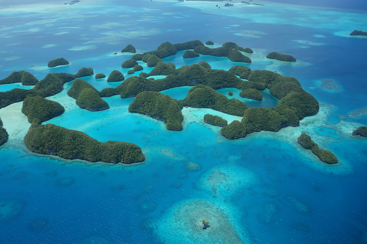
The Rock Islands Southern Lagoon, inscribed by UNESCO in 2012 as a mixed natural and cultural site, encompasses approximately 445 limestone islands and islets rising from the turquoise waters of Palau’s Southern Lagoon — a 100,200-hectare seascape in the western Pacific that contains some of the highest marine biodiversity on Earth. The islands’ characteristic mushroom-shaped profiles, widening above the waterline where the jungle canopy shades the rock and narrowing at the base where wave action and algae erode the softer limestone, make the Southern Lagoon one of the most immediately recognisable landscapes in the Pacific. Access is entirely by boat from Koror, the commercial hub of the Republic of Palau.
The marine ecosystem: coral, fish, and marine lakes Southern Lagoon, accessible by day-boat from Koror; 20–45 minutes depending on destination
The Southern Lagoon supports over 385 coral species, a figure that places it among the highest-diversity coral environments in the Pacific and indeed on Earth. More than 300 fish species have been recorded in the reef systems surrounding the Rock Islands, along with marine turtles, dugongs (Dugong dugon), and saltwater crocodiles (Crocodylus porosus), which inhabit the mangrove channels and inland waterways between the islands. The physical structure of the lagoon — a partially enclosed system protected by an outer barrier reef — creates the stable, warm, clear-water conditions that support this concentration of marine life. Visibility in the outer reef channels frequently exceeds 30 metres.
Within the Rock Islands, isolated geological processes have created an unusual category of habitat: marine lakes. These landlocked bodies of saltwater, cut off from the open ocean as the islands rose over millennia, developed their own distinct fauna in conditions quite different from the surrounding lagoon. The most celebrated is Jellyfish Lake (Ongeim’l Tketau on Eil Malk island), which contains millions of golden jellyfish belonging to the subspecies Mastigias papua etpisoni. These jellyfish have evolved in an environment with no significant predators — the anemones that would normally prey on jellyfish cannot survive in the lake’s oxygen-depleted lower layers — and over thousands of years have lost the functional stinging cells that characterise their oceanic relatives. Snorkelling through the upper water column of Jellyfish Lake, surrounded by millions of soft, pulsing animals ranging from golf-ball to dinner-plate size, provides an encounter with few parallels in wildlife travel anywhere.
The golden jellyfish migrate across the lake daily following the light — moving east with the morning sun and west through the afternoon — and congregate in a dense mass near the surface throughout the day. Seven additional named marine lakes in the Rock Islands contain their own distinct communities: some support small populations of different jellyfish species; others harbour unusual bivalves, sponges, or filter feeders that have adapted to the isolated, stratified conditions. The lakes collectively represent an ongoing natural experiment in island biogeography and evolutionary isolation, and several have been the subject of long-running biological research programmes.
Cultural heritage: ancient settlement, stone money, and the Second World War Cultural sites distributed across the Rock Islands and the main island of Babeldaob; boat access required
Archaeological evidence within the Rock Islands documents human settlement dating to approximately 3100 BCE, making Palau one of the earliest settled island groups in the Pacific. The ancient inhabitants used the Rock Islands intensively: as sources of stone (the hard limestone was quarried and worked), as sheltered fishing grounds, and as locations for ceremonial and residential sites. The carved stone faces known as dilukai — stylised female figures placed above the doors of traditional meeting houses (bai) as protective symbols — appear across Palau and indicate a distinctive artistic tradition with deep roots in the archipelago’s pre-contact culture.
Palau’s most internationally known material heritage, however, is the rai: large circular stone discs quarried from aragonite limestone on the island of Yap, approximately 450 km to the southwest, and transported back to Palau by canoe as a form of prestige currency. The Rock Islands were among the quarrying areas for this stone, which was worked into discs ranging from 30 centimetres to over 3 metres in diameter. Ownership of rai was a form of social capital that conveyed status and could be transferred in transactions without physically moving the stones — the community’s shared knowledge of ownership history constituting the record of value. Some rai quarried from the Rock Islands remain in situ on the islands or along village paths on Babeldaob.
Palau was a major Japanese naval base during the Second World War, and the lagoon contains dozens of sunken warships and aircraft from the conflict. The Battle of Peleliu, fought from September through November 1944 between Japanese and American forces on the small island of Peleliu in the southern Palau group, was among the most brutal engagements of the Pacific theatre: approximately 11,000 Japanese defenders held a honeycomb of concrete fortifications and caves against repeated American assaults over 73 days, at a cost of nearly 2,000 American dead and the near-total annihilation of the Japanese garrison. The wrecks in the lagoon — including the Zero-fighter aircraft, troop transports, and patrol vessels visible at recreational diving depths — constitute an underwater heritage landscape that attracts specialist divers. Palau gained independence in 1994 and is currently in free association with the United States; the capital is Ngerulmud on Babeldaob, though Koror functions as the main population and commercial centre. Visitors enter via Palau International Airport adjacent to Koror.
Practical information
Palau is served by direct flights from Manila, Seoul, Taipei, Guam, and Tokyo; connections via these hubs cover most international origins. All entry to the Rock Islands requires a Rock Islands permit, purchased at the dock in Koror; fees are charged per day and vary by activity (snorkelling, diving, and kayaking each carry separate fees). Access to Jellyfish Lake requires an additional fee and is managed by Koror State Government; visitor numbers are regulated and the lake has been temporarily closed in the past when jellyfish populations declined due to El Niño-related warming events — confirm current access before planning a visit. Reputable dive operators in Koror run guided day trips to the Rock Islands and can organise multi-day liveaboard itineraries that access more remote reefs and wreck sites. The driest and calmest months are roughly January through March; Palau receives significant rainfall year-round, but heavy tropical downpours are typically short. Water temperature stays above 28°C throughout the year. Sunscreen use is restricted in the Rock Islands (reef-safe alternatives only); some tour operators prohibit sunscreen entirely near Jellyfish Lake to protect the animals.
Frequently Asked Questions
How did the Rock Islands get their distinctive mushroom shape?
The mushroom profile visible across the Rock Islands results from differential erosion acting on the limestone at the waterline over thousands of years. The exposed surfaces above the waterline — capped with dense tropical vegetation whose roots help bind and protect the rock — erode relatively slowly. At the waterline, however, two mechanisms accelerate erosion in combination: wave action physically abrades and dissolves the carbonate limestone, and colonies of algae, boring sponges, and bivalves chemically and biologically attack the rock surface at the zone that is alternately wetted and dried by tidal movement. The result is a pronounced undercutting of the island mass at the waterline, leaving the upper portion of the island wider than the base and producing the characteristic stem-and-cap silhouette visible from the air or from a boat moving through the lagoon. The effect is most pronounced on islands where the limestone is relatively soft and the tidal range creates a concentrated erosion zone. The same process operates on limestone sea stacks throughout the tropical Pacific and Indian Oceans, but the density and variety of the Rock Islands — approximately 445 islands in a single lagoon — produces a landscape where the form becomes the dominant visual feature. UNESCO’s inscription specifically cited this geomorphology as an Outstanding Universal Value, alongside the biological richness it hosts.
What is the status of Jellyfish Lake and can visitors always enter?
Jellyfish Lake has been closed to visitors on at least two occasions since it became a major tourist attraction — most significantly during the 1998 and 2016 El Niño events, when elevated water temperatures caused dramatic declines in the jellyfish population. The golden jellyfish population in the lake collapsed from an estimated 30 million individuals to near zero during the 1998 event and took approximately a decade to recover to pre-closure densities. The lake was reopened and then closed again around the 2016 El Niño and reopened subsequently, but the pattern demonstrates that access is not guaranteed. The lake is managed by Koror State Government, which monitors population levels and retains authority to close the site when conditions warrant. Visitors planning specifically to swim with the jellyfish should check current access status directly with Koror State Government or with their tour operator before confirming travel plans, as closures can occur without long advance notice. When open, the lake is accessed by a 10-minute trail over a low ridge from the dock on Eil Malk island. Diving in the lake is prohibited because the bubbles from scuba equipment disturb the stratified water column and expose the jellyfish to the toxic, oxygen-depleted lower layer; snorkelling is the only permitted entry mode.
What did the Battle of Peleliu involve, and what remains to visit?
Peleliu, a small island approximately 45 km south of Koror, was selected by American planners in 1944 as a necessary objective before the anticipated invasion of the Philippines — the airfield on its northern plateau would otherwise threaten the American flank. What planners underestimated was the depth and sophistication of the Japanese defensive preparation. Under the command of Colonel Kunio Nakagawa, the Japanese garrison of approximately 11,000 men had constructed a network of interconnected caves, bunkers, and firing positions within the island’s coral ridgeline — a system designed for mutual support that made each position extremely difficult to neutralise. The American 1st Marine Division and later the Army’s 81st Infantry Division fought through this position for 73 days at costs that surprised both military planners and the American public. American losses were approximately 1,800 killed and 8,000 wounded; virtually the entire Japanese garrison was killed in action. The island today preserves extensive physical evidence of the battle: Japanese blockhouses, tank traps, ammunition dumps, artillery pieces, and the labyrinthine cave system in the Umurbrogol ridge (known during the battle as Bloody Nose Ridge) remain accessible on foot. A small museum near the airfield presents the campaign’s history from both American and Japanese perspectives. Day trips from Koror are available through tour operators.


