
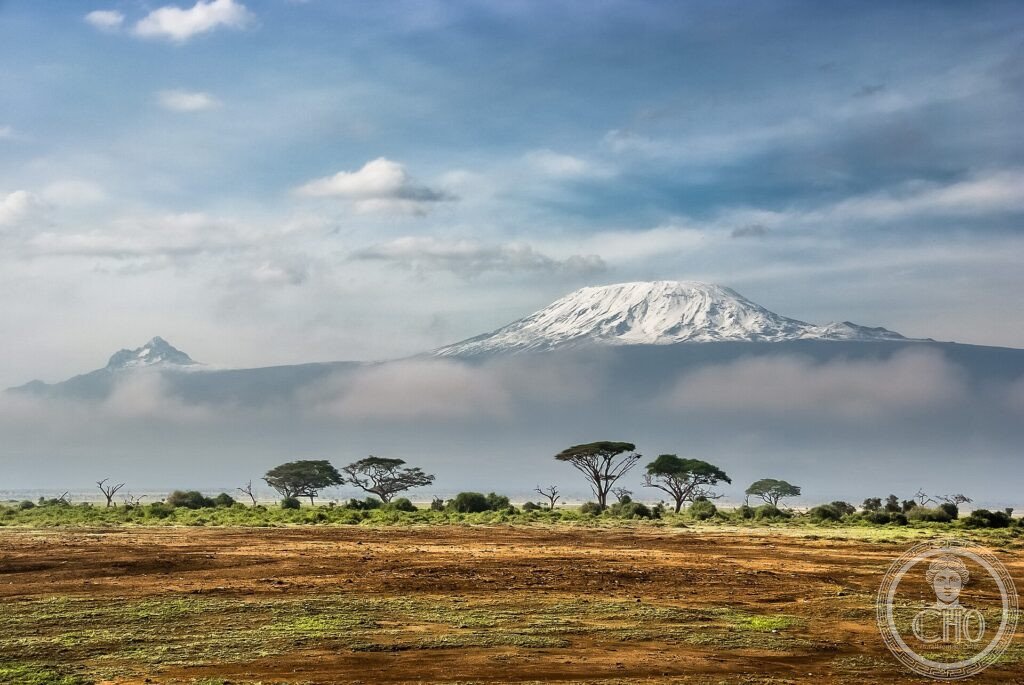
It rises alone from the African plain, crowned with snow a few degrees from the equator: Kilimanjaro, at 5,895 metres, is the highest mountain in Africa and the largest free-standing volcano in the world. From savannah to the ice of the summit, it holds every climate on Earth in one immense massif.
At a glance
Kilimanjaro National Park, in north-eastern Tanzania, protects the highest mountain in Africa: Mount Kilimanjaro, a free-standing volcano rising to 5,895 m, its flat summit crowned with glaciers and snow only a few degrees from the equator. From the surrounding savanna the mountain climbs through farmland, rainforest, moorland and alpine desert to the icy summit, passing through nearly every climate zone on Earth. This iconic mountain was inscribed by UNESCO in 1987.
Key facts
- UNESCO: World Heritage since 1987 (Kilimanjaro National Park)
- Highest in Africa: the summit reaches 5,895 m
- Free-standing volcano: the largest isolated mountain in the world
- Equatorial snows: glaciers near the equator (now shrinking)
- Climate zones: from savanna and forest to alpine desert and ice
- Uhuru Peak: the highest point, a goal for trekkers
History
Kilimanjaro is a dormant volcano built up over hundreds of thousands of years, its three cones — Kibo, Mawenzi and Shira — rising above the East African plains. Long known and revered by the Chagga and Maasai peoples who live around it, it astonished 19th-century European explorers with its equatorial snows, which were at first not believed.
Climbed for the first time to the summit in 1889, the mountain became one of the world’s great trekking goals, drawing thousands each year up its routes to Uhuru Peak. Protected as a national park and inscribed by UNESCO in 1987, it is also a powerful symbol of climate change, as its famous summit glaciers steadily retreat.
What you see
Trekking routes such as the Marangu and Machame trails climb the mountain over several days, passing from cultivated foothills and rainforest alive with monkeys, up through giant heather and otherworldly groundsels of the moorland, to the bleak alpine desert and the glaciers and crater of the summit. The reward is the dawn view from Uhuru Peak over Africa.
From the plains, the sight of the snow-capped flat summit floating above the savanna, often with elephants in the foreground, is unforgettable.
Practical information
- Park: the summit is reached on multi-day guided treks
- Best time: the dry seasons (January–March, June–October)
- Time needed: 5–9 days for a summit trek
- Note: high altitude; acclimatisation is essential
Getting there
Kilimanjaro National Park is in north-eastern Tanzania, near Moshi, reached via Kilimanjaro International Airport between Moshi and Arusha. GPS: 3.07° S, 37.35° E.
Nearby
- Moshi — the town at the mountain’s foot and trekking base
- Arusha — the safari capital, to the west
- Amboseli (Kenya) — the park across the border with classic Kilimanjaro views
Sources
- UNESCO World Heritage Centre — “Kilimanjaro National Park” (ref. 403)
- Tanzania National Parks (TANAPA) — official body
- Encyclopaedia Britannica — Mount Kilimanjaro
Find it on the map
See this place and what’s around it →📷 Become a Cultural Heritage Online photographer
Share your photos of places: they stay published under your name as the author. The more they're seen, the more you get noticed — and soon a contest will reward the most appreciated photos.
Log in or sign up free to add a photo