
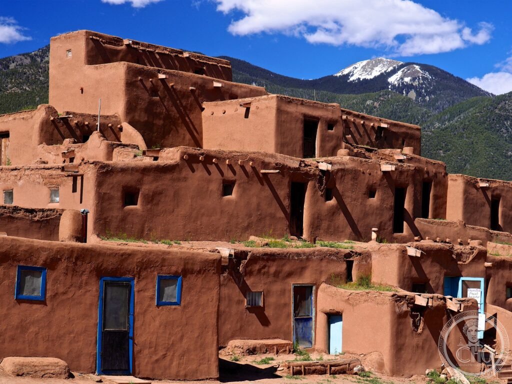
Taos Pueblo is one of the oldest continuously inhabited communities in the United States, its multi-storey adobe compounds built around the year 1000 and still home to families living without running water or electricity, divided by the sacred Rio Pueblo de Taos.
At a glance
Taos Pueblo stands in northern New Mexico and belongs to the Tiwa-speaking Taos people, one of nineteen surviving New Mexico Pueblo communities. The settlement has been occupied continuously for over a thousand years, and part of the community still lives inside the old adobe compounds without running water or electricity.
Two great multi-storey adobe complexes, the North Pueblo or Hlaauma and the South Pueblo or Hlaukwima, face each other across the Rio Pueblo de Taos, known locally as the Red Willow Creek. The stream flows down from Blue Lake on Taos Mountain, the most sacred site in Taos Pueblo religion, and remains the community’s only water source. Blue Lake was taken by the US government in 1906 and folded into the Carson National Forest; after a sixty-four-year campaign it was returned to the Taos Pueblo by President Nixon in December 1970, the first time sacred land taken from an Indigenous people had been given back by the American government.
Key facts
- Pueblo Revolt of 1680: Taos Pueblo was the meeting place where Popé, a religious leader from Ohkay Owingeh, organised the only successful Native American uprising against European colonisation, driving the Spanish out of New Mexico for over a decade.
- Adobe construction: the buildings are made of sun-dried mud and straw blocks with no mortar, hand-replastered periodically, walls thickest at the base, and entered from above by ladder through roof hatches rather than by interior stairs.
- San Geronimo Feast Day: held on 29 and 30 September, this is the pueblo’s principal public ceremony, combining Catholic and Pueblo tradition with dances, a foot race and a pole-climbing contest; photography of the ceremonies themselves is not allowed on this day.
- Blue Lake: restored to the Taos Pueblo in 1970 after decades of campaigning, it remains the sacred source of the Rio Pueblo de Taos.
- Coordinates: 36.4372° N, 105.5452° W.
History
Construction at the site by Ancestral Puebloan builders began around 700–900 CE, with the permanent multi-storey compounds seen today raised from roughly 1000 CE. The Taos people speak Tiwa, a language isolate with no known relatives outside the Pueblo world, still spoken by the community today.
The Spanish explorer Francisco Vásquez de Coronado led the first European expedition to Taos Pueblo in 1540. Franciscan missionaries founded the Mission of San Geronimo there in 1619. The following decades of Spanish colonial rule brought forced labour, suppression of traditional practice and confiscation of food stores, conditions that fed into the Pueblo Revolt of 1680, planned in secret at Taos and led from a kiva beneath the pueblo. The revolt killed around four hundred Spanish settlers and most of the Franciscan missionaries present, and kept the Spanish out of New Mexico for twelve years. The rebuilt mission church was later destroyed by US Army artillery under General Stephen W. Kearny following the Taos Revolt of 1847; its ruins still stand.
What you see
Visitors walk through the old compounds on foot as part of a guided visit. The Rio Pueblo de Taos runs through the centre of the site and is crossed by wooden footbridges to reach the North Pueblo; its water still supplies the households that live within the old walls. Kivas remain closed to anyone outside the tribal community.
At the south end of the pueblo stand the ruins of the Church of San Geronimo, rebuilt after the original 1619 church was destroyed in the 1680 revolt and later shelled in 1847. The adjoining cemetery is still in active use by the Taos Pueblo community.
Practical information
- Access: entry is by paid admission with guided tours available; check the pueblo’s own channels for current fees and any photography charges.
- Photography: photographing residents without explicit permission is prohibited, and all photography is barred during the San Geronimo Feast Day.
- Closures: the pueblo closes for several weeks each year, particularly between January and April, for ceremonial dances; it is worth confirming opening days directly with Taos Pueblo before travelling.
- Facilities: there is no running water or electricity inside the old compounds.
Getting there
Taos lies in northern New Mexico, about 130 km north of Santa Fe and 280 km north of Albuquerque, the nearest major airport. The drive from Santa Fe via the Taos High Road through the Sangre de Cristo Mountains is considered the more scenic approach. Taos Pueblo itself sits about 3 km north of the historic Taos Plaza and can be reached on foot or by short taxi ride.
Nearby
- Bandelier National Monument — about 100 km south, with Ancestral Puebloan cliff dwellings cut into volcanic tuff in Frijoles Canyon, including a Great Kiva and the detached Tsankawi unit.
- Santa Fe — about 130 km south, the oldest state capital in the United States, home to the Palace of the Governors, the Cathedral Basilica of St Francis of Assisi, the Canyon Road galleries and the Georgia O’Keeffe Museum.
- Taos Ski Valley — around 22 km northeast, a winter skiing destination.
- Rio Grande Gorge Bridge — around 29 km west, spanning the Rio Grande Gorge.
Sources
- Wikipedia, Taos Pueblo
- Wikipedia, Pueblo Revolt
- Wikipedia, Blue Lake (Taos)
- UNESCO, Taos Pueblo (World Heritage List reference 492)
Find it on the map
See this place and what’s around it →📷 Become a Cultural Heritage Online photographer
Share your photos of places: they stay published under your name as the author. The more they're seen, the more you get noticed — and soon a contest will reward the most appreciated photos.
Log in or sign up free to add a photoIs this page about you?
This page is read by travellers and heritage enthusiasts who find it on Google. Tell us how you are connected to this place and we will take it from there.