
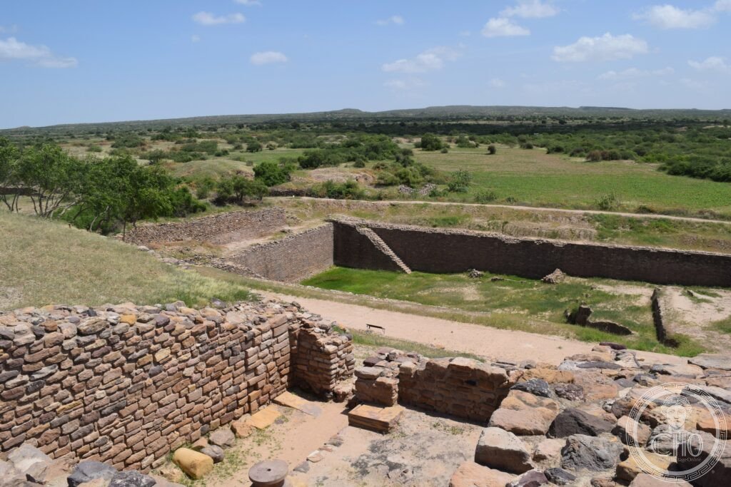
Dholavira is the most completely excavated city of the Indus Valley Civilisation, a fortified Harappan settlement on Khadir Island in the Rann of Kutch built around a ring of stone-lined reservoirs designed to store monsoon runoff through the dry season. It also holds the only known public inscription in the still-undeciphered Indus script.
At a glance
Dholavira stands on Khadir Island in the Rann of Kutch, one of the two largest Indus Valley cities found in India alongside Rakhigarhi. The Indus Valley Civilisation itself stretched across a vast area of the Indian subcontinent, encompassing roughly 1,500 known settlements, and Dholavira was occupied continuously for around 1,500 years before it was abandoned.
The site is best known for its water management system: a network of sixteen reservoirs, canals, drains and sluice gates that captured monsoon runoff and channelled it into storage covering about a third of the walled city. The stone-lined reservoirs remain visible today, some of considerable size and depth, and are generally regarded as the most sophisticated water infrastructure surviving from the ancient world before Greek engineering.
Key facts
- Civilisation and period: Indus Valley (Harappan) Civilisation, city occupied roughly 3000-1500 BCE.
- Rank among Harappan sites: the third-largest of the known Indus Valley settlements.
- Signature find: a large wooden signboard bearing ten Indus script characters, found at the North Gate — the largest known characters in the script and the only such public inscription discovered.
- City plan: three walled zones — a raised Citadel, a Middle Town and a Lower Town — enclosed within an outer perimeter.
- Ceremonial ground: a large open space between the Citadel and Middle Town, of unknown function, without parallel at Mohenjo-daro or Harappa.
- Excavation: carried out by the Archaeological Survey of India from 1989.
History
Dholavira’s decline around 1500 BCE coincides with the broader collapse of the Indus Valley Civilisation across its full extent. The leading explanation points to a long-term shift in the Indian Ocean monsoon that reduced rainfall over the Indus plains and Kutch, undermining cities whose water supply depended on captured monsoon runoff. The reservoir system that had sustained Dholavira for centuries became unsustainable once the rains failed.
Material recovered from the site reflects the wider Harappan culture: seals carved with animals such as the zebu bull, the tiger and the rhinoceros, used to authenticate trade goods; standardised weights following the same ratio system used from Mesopotamia to Central Asia; carnelian and lapis lazuli beads, the lapis brought from Afghanistan; and evidence of copper casting and black-slipped pottery.
What you see
The sixteen reservoirs, catalogued by the Archaeological Survey of India, form a ring around the periphery of the city, with the largest examples on the south side of the Citadel. Each is stone-lined and fitted with sluice gates, and the channels that once connected them are still traceable as shallow depressions in the ground. Seeing the scale of this engineering, achieved without metal tools or a known hydraulic tradition, is the most striking part of a visit.
A site museum near the North Gate, run by the Archaeological Survey of India, displays a replica of the signboard along with original seals, weights, jewellery, pottery and scale models of the reservoir system. The original signboard itself is now held at the National Museum in Delhi.
Practical information
- Access: the site and museum are open to visitors; current entry arrangements and timings should be checked with the Archaeological Survey of India or the site’s official channels before travelling.
- Best season: the cooler months are recommended, since summer heat is extreme and the access road can be affected by monsoon flooding.
- Accommodation: basic guesthouses are available in Dholavira village; booking ahead is advisable.
Getting there
Bhuj is the nearest major city, with an airport served by flights from Mumbai and Ahmedabad. From there a paved road crosses the Rann of Kutch to reach Dholavira; the landscape en route is remote and sparsely served by petrol stations, so travellers are advised to carry water and fuel supplies. A bus service also runs from Bhuj.
Nearby
- White Rann of Kutch — a short drive north, the salt desert of the Great Rann of Kutch, dry for much of the year and flooded during the monsoon; home to migratory flamingos and the setting for the Rann Utsav festival.
- Rani ki Vav, Patan — roughly 200 km east, an 11th-century stepwell of the Solanki dynasty, richly carved and inscribed as a UNESCO World Heritage Site in 2014; Patan was Gujarat’s medieval capital before Ahmedabad.
Sources
- Wikipedia, Dholavira.
- Wikipedia, Indus Valley Civilisation.
- Wikipedia, Indus script.
- UNESCO, Dholavira: a Harappan City, WHS reference 1645.
Find it on the map
See this place and what’s around it →📷 Become a Cultural Heritage Online photographer
Share your photos of places: they stay published under your name as the author. The more they're seen, the more you get noticed — and soon a contest will reward the most appreciated photos.
Log in or sign up free to add a photo