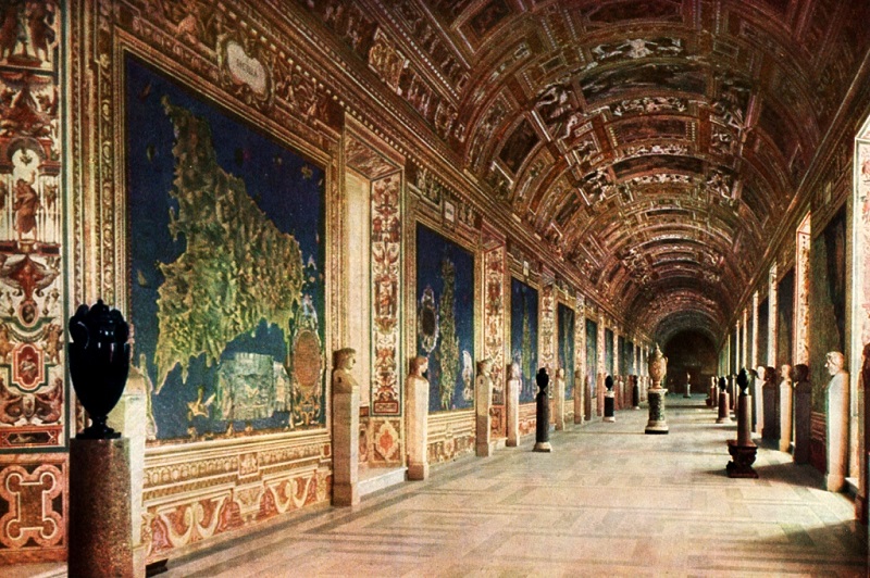
Gallery of Geographical Maps - Vatican Palaces

The Gallery of Geographical Maps is located in the Vatican Palaces and is now included in the perimeter of the Vatican Museums in Rome. The gallery is located along the itinerary that leads to the Sistine Chapel; it is an exceptional cartographic representation of the regions of Italy, made between 1580 and 1585. It thus constitutes a precious testimony of the geographical knowledge and the state of the places at that time.
The document is also remarkable because in the papal palace of the time the geographical and spiritual unity of the whole of Italy was already affirmed.

It is a corridor 120 meters long and six wide, on the walls of which forty maps of the various regions of Italy are depicted, each with maps of the main cities, and ends with views of the main Italian ports of the sixteenth century: Civitavecchia, Genoa, Ancona and Venice. Each region map is accompanied on the ceiling by representations of the main religious events that took place in it.

It was Pope Gregory XIII who ordered the construction of the gallery, and the work was directed by the mathematician, geographer and friend of Pope Ignazio Danti, a Dominican, who took care of its construction between 1581 and 1583. Walking through the gallery is, according to the intentions of Ignazio Danti, such as traveling along the Apennines and looking out over the Adriatic coast, towards the east, and the Tyrrhenian coast, towards the west. In fact, the regional maps and the views of the ports that complete the gallery are distributed on the two walls: the Adriatic ones to the right and the Tyrrhenian ones to the left.
The artists who worked there were Girolamo Muziano, Cesare Nebbia, the two Flemish brothers Matthijs Bril and Paul Bril, Giovanni Antonio Vanosino da Varese and Antonio Danti who decorated and frescoed it between 1580 and 1585, following the instructions of Ignazio Danti, a native of Perugia.
The vault is painted by Antonio Tempesta of Florence and others.
Video: Gallery of Geographical Maps - Vatican Palaces
Map: Gallery of Geographical Maps - Vatican Palaces
Address: Palazzi Vaticani, VA, 00120 - Stato del Vaticano
Roma (RM) Lazio
Latitude: 41.90410165863872
Longitude: 12.45423138141632
Site: https://www.vaticanstate.va/it...
vCard created by: CHO.earth
Currently owned by: CHO.earth
Type: Palace
Function: Museum
Creation date: 29-10-2019 13:02
Last update: 07/07/2022